How I Capture Venues in Complex Terrain with Flip
How I Capture Venues in Complex Terrain with Flip
META: A practical tutorial for filming venues in uneven landscapes with Flip, using safe altitude choices, obstacle awareness, tracking modes, and newsroom-inspired aerial storytelling.
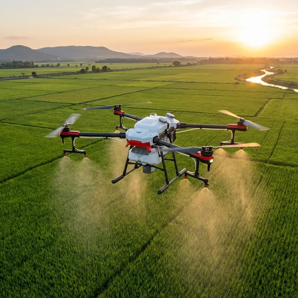
When a venue sits in complex terrain, the drone is not just a camera in the sky. It becomes a tool for solving visibility problems that the ground simply cannot handle.
I think about hillside resorts, cliffside event spaces, vineyard stages, amphitheaters cut into valleys, and retreat centers tucked between tree lines. These locations look dramatic in person, but they are notoriously difficult to photograph well. Elevation changes compress oddly in ground shots. Access roads distract from the setting. Trees, ridgelines, and building edges can hide the venue’s true layout. A clean aerial workflow changes that.
That is why the story behind CNN’s move into drone newsgathering still matters. The company disclosed that it had reached an agreement with the U.S. Federal Aviation Administration to use drones domestically for gathering news footage. That may sound like a media policy milestone, and it was, but the operational lesson is bigger than journalism. A major broadcaster was effectively acknowledging that some stories cannot be covered properly without aerial perspectives. CNN also said it wanted to use multiple unmanned aircraft and camera devices to gather high-quality footage. That detail is especially relevant for venue capture in complex terrain, because one angle is rarely enough when the land itself is part of the subject.
I approach Flip the same way. Not as a novelty. As a professional framing tool.
This tutorial breaks down how I use Flip to capture venues in uneven landscapes, with a focus on altitude, route planning, camera behavior, and the smart modes that help without taking creative control away.
Why complex terrain changes everything
A flat venue is easy to read from above. A venue surrounded by elevation shifts is different. Terrain creates three recurring problems.
First, vertical separation distorts scale. A reception terrace on a ridge may look disconnected from the parking area below, even though the walk between them is short. Second, foreground obstacles become more aggressive. Trees, poles, roofs, and rock faces enter the frame faster than you expect when flying laterally. Third, the venue often needs context to make sense. You are not only filming a building or stage. You are showing how that place fits into the valley, shoreline, slope, or forest edge around it.
That is exactly why features like obstacle avoidance, ActiveTrack, subject tracking, QuickShots, Hyperlapse, and D-Log matter in this scenario. They are not buzzwords. They reduce workload while preserving the shape of the story.
If I am documenting a venue for marketing, planning, or editorial use, my job is to answer visual questions clearly:
- Where is the venue in relation to the surrounding land?
- How do guests or visitors approach it?
- What terrain constraints shape the experience?
- Which viewpoints make the location feel expansive rather than cramped?
- How can I show movement through the site without risking unstable or cluttered shots?
Flip is most useful when it helps answer those questions efficiently.
Start with altitude, not movement
Most pilots think first about the shot type. I start with flight altitude.
In complex terrain, altitude is the control variable that decides whether the venue reads cleanly or disappears into visual noise. Fly too low and every tree, railing, and roofline competes with the subject. Fly too high and the venue loses emotional presence.
My practical starting point is this: begin with a pass at roughly 1.5 to 2 times the height of the tallest nearby obstacle above the venue’s immediate visual plane, then adjust based on slope and subject size.
That is not a legal recommendation. It is a framing method. If the tallest nearby tree line or structure is around 20 meters relative to the venue’s usable foreground, I usually begin testing at around 30 to 40 meters for a reveal or mapping-style establishing pass. In steeper terrain, I often increase that slightly because ridgelines rise into frame faster than they appear to from the takeoff point.
This is the single most useful altitude insight I can give for venue capture in complex terrain: choose an altitude that clears the visual clutter, not just the physical obstacles.
Those are not always the same thing.
A safe low pass may still be a bad visual choice if the venue is constantly being cut by foreground branches or roof edges. When I see that happening, I do not immediately blame the route. I climb first. A modest altitude increase often creates a cleaner frame than a more complicated maneuver ever will.
Use the terrain to design your opening shot
The best venue footage usually begins by revealing geography before detail.
That is one reason the CNN reference is so instructive. The company was not simply interested in drone footage because drones are efficient. It wanted more professional tools for journalism and intended to work with multiple aircraft and camera setups. Operationally, that tells us something important: different aircraft positions serve different narrative functions. One shot establishes the location. Another isolates action. Another explains access, crowd flow, or environmental conditions.
With Flip, I build that logic into a small-shot sequence.
For a venue in complex terrain, my opening sequence usually follows this order:
- A high establishing shot that shows the venue’s relationship to slope, water, road, or tree cover
- A controlled forward approach that makes the site feel reachable
- A side-angle drift or arc to reveal elevation change
- A lower detail pass for architecture, entrances, seating, staging, or landscape design
This sequence works because it mirrors how people understand place. First the setting, then the path, then the shape, then the details.
QuickShots can help here, especially when I need repeatable motion for a clean reveal. I do not use them blindly. I use them when I already know what structural information the shot needs to deliver. In rugged terrain, automation is useful only if the background layers are readable. A dramatic move that confuses the site layout is not doing its job.
Obstacle avoidance is not permission to get sloppy
Complex venues often tempt pilots into aggressive low-altitude work. Stone walls, pergolas, cable lines, tree canopies, and terraced gardens look fantastic from a tight angle. They also punish poor planning.
Obstacle avoidance is valuable here, but only if you treat it as backup rather than strategy.
I use it most when the terrain creates partial visual traps, such as flying along a curved access road where a stand of trees suddenly narrows the corridor, or when tracking motion near elevation changes that reduce depth perception. Flip’s obstacle-awareness features can buy time and reduce stress in those moments, but they do not replace a deliberate route.
My rule is simple: pre-visualize the shot at a safer altitude, then descend only after I understand the terrain layers.
If a venue sits on a stepped hillside, I will often fly a slower reconnaissance pass first to identify hidden obstacles that do not stand out from the takeoff zone. This matters because terrain changes your eye level constantly. Something that looks safely below the drone from one side of a slope may become a direct conflict point once you arc around the subject.
ActiveTrack and subject tracking for venue storytelling
When people hear subject tracking, they usually think of athletes, vehicles, or presenters. For venue work, I often track movement through space instead.
That could be a shuttle cart approaching the entrance, a wedding party walking a ridge path, event staff moving between structures, or a visitor group crossing an overlook. The point is not speed. The point is scale.
A static venue shot can look beautiful yet still fail to communicate how the place works. Add a moving subject, and the venue suddenly becomes legible. Path widths make sense. Staircases show their grade. Courtyards reveal proportion. Distances between amenities become intuitive.
ActiveTrack is especially useful when the terrain is visually busy and manual composition would otherwise become too demanding. I still monitor framing aggressively, but letting Flip maintain lock on a moving subject frees me to think about altitude discipline and background cleanup.
The best tracking results in complex terrain usually come from modest speeds and diagonal compositions. Straight chase shots often flatten the slope. A slightly offset angle shows both the subject and the rise or fall of land, which is exactly what venue clients, planners, and media teams need to see.
D-Log matters more than people think
Uneven terrain creates contrast problems that ruin otherwise excellent footage.
Venues built into hillsides or coastal edges often combine bright sky, reflective surfaces, shadowed vegetation, and dark architectural recesses in the same frame. If you expose only for the obvious subject, you can lose texture in the land around it, and that land is often what makes the venue special.
That is where D-Log becomes useful. I rely on it when I know the final deliverable needs flexibility in grading, especially during sunrise, late afternoon, or mixed-shadow conditions. It gives me more room to preserve highlight detail in the sky while keeping enough information in the darker terrain and structures.
Operationally, this matters because venue footage is rarely used in only one context. The same aerial clips may appear in a website header, a planning presentation, a tourism piece, or editorial coverage. A flatter capture profile gives more room to adapt the footage without baking in harsh contrast too early.
Hyperlapse for terrain-driven context
Hyperlapse is one of the strongest tools for explaining venue geography, provided the route is simple and the purpose is clear.
I use it less as a flashy effect and more as a compression tool. On a large venue site spread across elevation bands, Hyperlapse can show the transition from access road to arrival point or from outer landscape to main event zone in a way that a single static shot cannot.
The key is restraint. The route should clarify the venue’s relationship to terrain, not distract from it. Smooth, predictable paths work best. In complex environments, I favor routes that travel along the terrain contour or gently rise with the land. That keeps the audience oriented.
If the goal is promotional storytelling, Hyperlapse is often strongest between major sequences rather than as the hero shot itself.
My preferred capture workflow with Flip
For photographers and content teams working these locations, here is the field approach I trust most:
Arrive early enough to study the venue from the ground first. I look for three things: the highest clutter source, the cleanest approach line, and the angle that best explains the terrain. Then I launch for a non-hero scouting pass at conservative altitude.
Next, I capture the establishing sequence while the light is still clean and the site is not visually crowded. Once I have that, I move into directional shots that show access and movement. After that, I work lower for detail passes only where the terrain has already been understood.
If people or vehicles are part of the story, I bring in ActiveTrack or subject tracking selectively. If the dynamic range is challenging, I switch to D-Log. If the site needs a geography bridge, I add a Hyperlapse. If I need fast, repeatable reveal motions, I may use QuickShots after checking obstacle spacing.
That layered workflow reflects the same professional instinct seen in the CNN reference: aerial coverage becomes valuable when it expands what the audience can understand. High-quality footage is not just a technical target. It is an information target.
If you are mapping out your own venue workflow and want to compare route ideas for a tricky site, you can send a sample location through this WhatsApp line for flight-planning discussion.
What makes Flip effective for this kind of work
Flip stands out in venue capture when you use its intelligent features to support a deliberate visual plan instead of replacing one.
For complex terrain, that means:
- Obstacle avoidance helps maintain safer margins near layered foreground elements
- ActiveTrack and subject tracking make human-scale movement easier to integrate
- QuickShots speed up repeatable reveal structures
- Hyperlapse compresses large elevation-based transitions into readable sequences
- D-Log protects tonal detail when terrain and architecture create contrast extremes
Used together, these tools help turn a difficult site into a coherent visual story.
And that is the real connection back to the CNN example. Once drone use moved beyond narrow exceptions and into professional image gathering, the value proposition became clear: aerial systems are not just for seeing more. They are for understanding more. CNN’s interest in using multiple unmanned aircraft and camera devices for high-quality reporting reflects the same truth venue photographers deal with every week. A single perspective rarely explains a complex place.
With Flip, the goal is not to overcomplicate the mission. It is to choose the right altitude, read the land honestly, and let each flight mode serve the story of the venue.
Ready for your own Flip? Contact our team for expert consultation.