Flip for Dusty Vineyard Mapping: A Practical Flight
Flip for Dusty Vineyard Mapping: A Practical Flight Workflow That Holds Up When Conditions Shift
META: Learn how to use Flip in dusty vineyard conditions for modern mapping and imaging, with a field workflow built around flight control, real-time monitoring, image reliability, and changing weather.
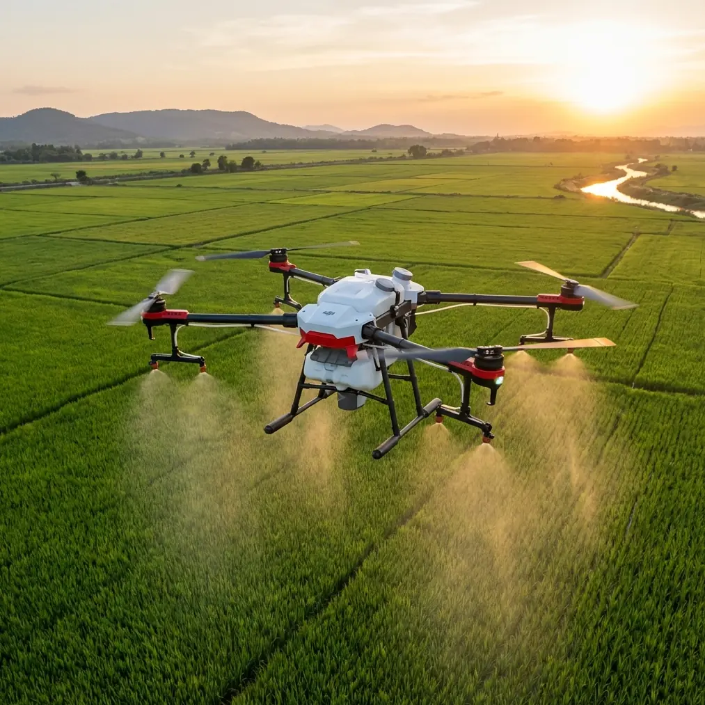
Vineyards look calm from the road. They rarely are from the air.
Dust hangs over access tracks. Light changes by the minute. Wind slips between rows, then spills across open ground at the edge of a block. If you are trying to capture usable aerial data rather than just pretty clips, those variables matter more than the drone’s spec sheet headline.
That is where the conversation around Flip gets more interesting.
For vineyard work in dusty conditions, the real question is not whether a drone can get airborne and record footage. Most can. The question is whether the aircraft, pilot workflow, and capture logic can keep producing reliable visual information when the field environment stops cooperating. That distinction sits at the center of modern UAV mapping practice, and it aligns with a point long recognized in professional surveying: the value of a drone system comes from the whole chain, not just the flying camera.
A useful reference from a 2015 Chinese surveying paper on UAV use in modern mapping made that clear. It described the ground control side as the key part of flight control, built around a portable computer, antenna, power system, and monitoring software. Operationally, that matters because mapping quality starts before takeoff. The system must set flight parameters, track navigation and dynamic aircraft status, and keep the aircraft on a planned route so data collection happens at the intended points rather than wherever conditions push it.
That principle still applies when using Flip over vineyards. In fact, dusty agricultural environments make it even more relevant.
Why vineyards demand a mapping mindset, not a casual flying mindset
A vineyard is full of repeating geometry. Rows, trellis lines, turning lanes, patches of exposed soil. That repetition can be visually beautiful, but it also exposes weak flight planning fast. If your route wanders or your altitude shifts too much, your footage may still look cinematic while becoming much less useful for analysis, comparison, or future repeat missions.
The surveying reference emphasized that UAV systems are valuable because they can deliver accurate and timely information, supported by high-resolution imagery and rapid acquisition. That is not academic language. In a vineyard, “timely” can mean documenting dust impact after vehicle movement, spotting drainage issues after a weather shift, or recording block conditions during a narrow operational window before workers or machinery move through.
Flip fits best when you treat it as an agile imaging platform for fast-response visual capture. Dusty vineyard work rewards exactly that approach: get in, follow a controlled plan, gather clean overlapping views, and adapt the moment the air changes.
Start with the ground side, not the props
One of the most overlooked truths in drone operations is that the aircraft is only half the system. The older surveying framework named the ground control system as the critical flight-control component because that is where route parameters, monitoring, and real-time flight decisions come together.
In practical Flip terms, your field success in a vineyard begins with these preflight decisions:
- Define the purpose of the mission. Are you documenting row uniformity, canopy gaps, access-road dust, irrigation line visibility, or promotional footage with mapping value?
- Build a route that respects the geometry of the vineyard. Long straight passes parallel to rows are usually easier to repeat later.
- Choose a safe and consistent working altitude. The reference notes that many UAV mapping operations are flown below 1000 m, which reflects a low-altitude logic designed for high-detail imaging. In vineyards, you are typically working far lower than that, and the significance is simple: low-altitude capture gives you stronger local detail and more useful large-scale visual records.
- Monitor live flight data continuously. Pitch, roll, yaw, speed, position, and altitude are not abstract telemetry fields. They tell you whether the aircraft is truly executing the mission you planned.
Flip users often focus first on creative tools like QuickShots, Hyperlapse, or ActiveTrack. Those can be useful, but in dusty vineyards they should sit on top of a disciplined flight structure, not replace it.
A field-tested workflow for dusty vineyard capture with Flip
Here is the workflow I recommend when the assignment is “capturing vineyards in dusty conditions” and the goal is usable, repeatable results.
1. Walk the launch area first
Dust changes everything at ground level. Before unfolding Flip, look at:
- vehicle movement nearby
- loose topsoil on access roads
- direction of crosswind over open sections
- nearby obstacles such as posts, wires, tree lines, and irrigation hardware
This is where obstacle avoidance becomes more than a convenience feature. Vineyard boundaries and utility lines can create awkward approach angles, especially when visibility softens in airborne dust. A system that helps maintain spatial awareness reduces pressure on the pilot when conditions become less readable.
Choose a launch spot slightly offset from the dustiest traffic lane if possible. You want cleaner takeoff air and a better chance of keeping the lens and lower body surfaces clear.
2. Build your first pass for information, not drama
The first flight should answer questions.
Fly a simple route along the row direction, then one cross-row segment if space allows. Keep your speed measured. The 2015 surveying paper highlighted the importance of acquiring high-overlap imagery because overlap improves downstream reliability. Even if you are not creating a formal survey product on every mission, the lesson holds: do not race through the block. Give yourself image continuity.
This is where D-Log can become valuable if the light is unstable. Vineyards in dusty air often produce low-contrast scenes with bright sky and muted ground detail. A flatter capture profile preserves room for later grading and detail recovery, especially when you need to compare canopy texture against dusty tracks or shadowed row interiors.
3. Use subject tracking selectively
ActiveTrack and subject tracking can help if your brief includes following a tractor, utility vehicle, or walking inspection along vineyard lanes. But use it carefully in dust.
Dust clouds can temporarily reduce contrast and make autonomous tracking less confident. If the target path runs close to posts or boundary vegetation, manual oversight becomes essential. The point is not to avoid intelligent tracking. The point is to treat it as an assistant, not the decision-maker.
When used well, ActiveTrack helps maintain consistent framing while you watch the broader airspace and telemetry. In agricultural capture, that division of attention can be genuinely useful.
4. Save QuickShots for context pieces
QuickShots are excellent for short establishing clips: a reveal over rows, a gentle pullback to show block structure, or a rising perspective that frames the vineyard in its broader terrain.
What they should not do is replace your core documentation passes.
A vineyard operator, grower, or land manager often needs visual clarity more than cinematic novelty. Capture the dependable record first. Then add the polished context shots. That order keeps the mission useful even if weather cuts the flight short.
5. Watch weather like it is part of the subject
It is.
The reference article described UAV mapping as an important facility for emergency surveying support because it can obtain accurate and timely imagery quickly. In vineyard work, “emergency” does not have to mean disaster. Sometimes it means the weather turning halfway through your sortie and forcing a faster decision cycle.
I had a flight like that while filming rows in a dry block where vehicle traffic had left a fine layer of dust over the access lanes. The air was stable during setup. Mid-flight, the light flattened, the crosswind freshened, and dust started lifting in small sheets from the track at the edge of frame. Suddenly the mission changed.
This is where a well-managed drone setup proves its worth.
Instead of chasing the original creative plan, I switched priorities. I shortened the route, held a more conservative line over the cleaner interior rows, and watched live position, speed, and aircraft attitude more closely. That operational discipline mirrors the surveying logic in the reference: flight parameters, dynamic information, and route control are not background functions. They are what let the drone keep collecting targeted information when conditions shift.
Flip handled the change because the mission became simpler, not more ambitious. That is a useful lesson. When weather turns, the smartest move is often to reduce variables. Fewer aggressive moves. More stable passes. Cleaner exits.
6. Use Hyperlapse only if the air is stable enough
Hyperlapse can create striking vineyard visuals, especially for showing moving shadows, vehicle patterns, or changing atmosphere across rows. But dusty air complicates it.
If the wind is building or dust is thickening, Hyperlapse may exaggerate inconsistency rather than produce something elegant. The result can look busy and thin on detail. Use it when conditions are steady enough for the repeated frames to stay coherent. If the weather is in transition, skip it and focus on shorter controlled sequences.
Why low-altitude imaging still matters in vineyard operations
One of the strongest points in the reference material is that UAV systems offer a major advantage in local information capture because they work at relatively low altitude and can produce high-resolution imagery. That matters a lot in vineyards.
A higher, broader view may show the property. A lower, disciplined pass shows condition.
You can see dust concentration on roads, breaks in canopy continuity, wheel-track patterns, row-end congestion, and localized terrain change. That kind of local visual evidence is often what operators actually need to make field decisions. The drone is not valuable because it is airborne. It is valuable because it turns a changing site into readable information fast.
That is also why repeatability matters. If you can return later and fly the same route with similar framing, the comparison becomes far more useful than a one-off dramatic clip.
Handling dust without overcomplicating the mission
Dusty conditions tempt pilots into constant adjustment. Resist that.
A cleaner workflow is:
- take off from the least disturbed surface available
- gain safe height before moving into the block
- avoid low hovering over active dust plumes
- keep route geometry simple
- prioritize stable straight-line passes
- land before visibility or surface gusts deteriorate
This is also where subject tracking and obstacle avoidance need to be balanced with human judgment. Vineyard environments are structured but not empty. Wires, poles, uneven edges, and occasional moving equipment create enough complexity that you should never rely blindly on automation.
Flip’s real advantage in this scenario
For dusty vineyard capture, Flip’s value is not one single feature. It is the ability to combine intelligent flight assistance with a disciplined imaging workflow.
Obstacle avoidance helps preserve margin in tight agricultural spaces. ActiveTrack can support moving-subject sequences when used carefully. QuickShots and Hyperlapse can add visual context once the essential passes are secured. D-Log helps preserve flexibility in scenes where dusty air and shifting light reduce contrast.
But the bigger story is operational.
The older surveying framework described UAV systems as crucial for improving the timeliness and relevance of mapping results and supporting faster access to dynamic geographic information. That same logic now applies to agricultural imaging on a much more accessible scale. A vineyard manager does not need abstract aerial footage. They need current, clear, targeted visual information. Flip becomes useful when it serves that need directly.
A simple mission template you can reuse
If you want a repeatable starting point for dusty vineyards, use this sequence:
- Preflight from a clean launch area.
- Establish wind direction and dust movement.
- Fly one straight mapping-style pass along rows.
- Fly one return pass with slightly adjusted framing for overlap and comparison.
- Capture one wider context shot.
- Add a short tracked segment only if visibility and obstacle spacing support it.
- Land early if the weather trend worsens.
That workflow is not flashy. It works.
And that is the point. Good vineyard drone work is usually less about squeezing every feature into one sortie and more about collecting reliable imagery under imperfect field conditions.
If you are refining your own Flip workflow for agricultural capture and want to compare setup ideas or route planning options, you can message the team here and discuss the scenario directly.
The best drone operators in agriculture do not just fly well. They think like field technicians. They understand that every pass should produce information that stays useful after the excitement of the flight is over.
In dusty vineyards, that mindset separates random footage from meaningful aerial documentation.
Ready for your own Flip? Contact our team for expert consultation.