Delivering Construction Sites in Complex Terrain with Flip
Delivering Construction Sites in Complex Terrain with Flip: Flight Altitude Tips That Actually Hold Up
META: Learn how to use Flip for construction-site delivery and site documentation in complex terrain, with practical flight altitude guidance grounded in UAV photogrammetry results and real operational constraints.
Construction sites in broken terrain punish vague advice.
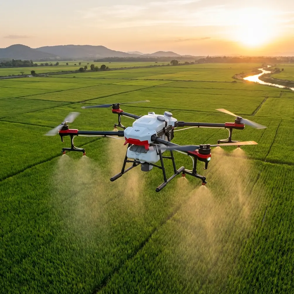
A drone that flies beautifully over a flat open field can become awkward the moment you bring it into cut slopes, temporary access roads, stacked materials, cranes, retaining walls, and uneven elevation. If you are using Flip around these environments, the biggest tactical mistake is usually not speed, camera mode, or route planning. It is altitude selection.
Get altitude wrong and everything else starts to wobble. Obstacle avoidance becomes less useful. Tracking becomes less reliable. Hyperlapse and QuickShots turn from useful visual tools into awkward gimmicks. Even something as simple as documenting a material drop zone can become inconsistent from one flight to the next.
What makes this more interesting is that the best altitude logic for a construction site is not just a matter of avoiding objects. It also overlaps with a principle proven in a rural land-rights mapping project in Heilongjiang: a UAV system using a PPSG UAV and a non-metric camera collected low-altitude remote-sensing data over a 2.5 km² test area near Shuangyashan, then processed the imagery with professional aerial triangulation software to produce DOM and DSM outputs that met 1:1000 mapping accuracy standards. That matters because it shows a practical truth many operators still underestimate: you do not always need a specialized metric camera or a very high flight profile to generate reliable, usable spatial results. Low-altitude capture, if planned properly, can be precise enough for real land administration work.
For construction delivery and site observation with Flip, that same idea translates directly. Low enough to preserve detail. High enough to keep terrain and structures from surprising the aircraft. Repeatable enough that your footage and your site records remain useful over time.
Why altitude is the real control variable on difficult sites
On a construction site in complex terrain, “altitude” is never just one thing.
There is your takeoff elevation. Your actual height above the local ground. Your height relative to nearby structures. Your height relative to a ridgeline or excavation edge. And there is the visual perspective your camera sees, which affects whether the flight is useful for logistics confirmation, progress records, or stakeholder updates.
Flip operators often think first about the destination point. I would reverse that. First establish the terrain envelope, then build the route and delivery profile around it.
This matters because rugged sites create false confidence. You may launch from a pad that feels open and safe, climb to what seems like a comfortable height, then fly toward an area where the terrain rises under the aircraft. Suddenly a conservative-looking altitude becomes tight. Obstacle avoidance can help, but obstacle systems are not a substitute for terrain discipline. Their real value is as a protective layer around a well-planned altitude, not as permission to improvise.
That is also where the reference study becomes more than an academic footnote. The project’s use of low-altitude imagery and later software-based processing shows the operational power of planned capture geometry. In simple terms: if the flight profile is intentional, modest onboard imaging hardware can still produce accurate results. For Flip, this is a reminder that careful height selection often beats brute-force flying higher “just to be safe,” especially when you need usable detail of roads, stockpiles, handoff points, or access corridors.
The best starting rule for Flip in complex terrain
If you need one practical rule, use this:
Set your working altitude from the highest terrain or structure along the route, not from the takeoff point.
That sounds basic, but many inconsistent flights come from ignoring it.
On stepped or sloped construction sites, I like to think in three altitude bands:
1. Low working band
Use this when you need detailed visual confirmation of a delivery point, path obstruction check, or a precise look at temporary works.
This is where Flip can make obstacle avoidance, ActiveTrack-style subject following, and detailed imaging genuinely useful. But only when the route is short, the terrain is well understood, and vertical surprises are limited.
A low working band is also where non-metric imaging becomes most productive. The Heilongjiang land-rights example relied on low-altitude data capture to support outputs accurate enough for 1:1000 mapping. The lesson for a construction operator is straightforward: lower altitude often means stronger visual detail and better interpretability, as long as overlap, route control, and safety margins are handled properly.
2. Transit band
This is usually the safest default for moving across uneven sections of the site.
You climb enough to clear changing terrain, rebar cages, temporary equipment, and staged materials with margin. You may lose some fine detail compared with low flight, but you gain consistency. This is often the sweet spot for sites with multiple elevation changes.
For routine delivery runs between a staging area and a work face, this tends to be the band that keeps the mission repeatable. Repeatability matters more than dramatic low passes. A construction manager wants confidence that the route works every time, not a cinematic flight.
3. Overview band
Use this for site-wide situational awareness, progress records, stakeholder updates, or route planning before lower operational flights.
This is where Hyperlapse and wide establishing footage can help, particularly if you are documenting earthworks progression or access changes through the week. It is also the cleanest altitude for creating consistent visual references over time.
But there is a tradeoff. Once you go too high, you reduce the practical value of obstacle sensing near finer site features and can lose clarity at the exact handoff area. So the overview band is for planning and communication, not for the final delivery approach.
Optimal flight altitude is not one number
People ask for a number. They want “the best altitude” for Flip on a mountainous or stepped construction site.
That is not how good site operations work.
The right altitude depends on four things:
- vertical variation across the route
- tallest temporary or fixed obstacle
- required image/detail level
- the delivery phase of the flight
If you are conducting a route reconnaissance pass, fly higher than you would for a close visual confirmation of the drop zone. If you are recording site progress for engineering review, fly at a repeatable height that preserves perspective consistency rather than chasing dramatic proximity.
A useful method is to divide the mission into phases:
- Recon pass at a conservative overview altitude
- Transit run at a stable middle altitude
- Approach segment lowered only when the terrain and obstacle picture is fully understood
- Exit climb back to a safer transit profile
This structure gives Flip room to use its obstacle sensing intelligently while keeping your camera output useful. It also reduces the common temptation to stay too low for the entire route.
What the rural land-rights project teaches Flip operators
The reference paper was not about construction delivery. Still, two details from it are highly relevant.
Detail one: a non-metric camera was enough
The UAV carried a non-metric camera, not a specialized survey camera. Yet after image processing, the system still produced digital orthophotos (DOM) and a digital surface model (DSM) with acceptable precision for 1:1000 scale mapping.
Operational significance for Flip: your workflow matters as much as the sensor. If you want useful construction-site outputs, do not obsess only over hardware labels. Consistent altitude, intentional overlap, stable flight lines, and disciplined capture timing can dramatically improve what you get from the platform. For site records, haul-route checks, stockpile review, and terrain-change observation, disciplined flying often beats chasing more equipment.
Detail two: low-altitude flexibility was a core advantage
The paper emphasized several advantages of UAV photogrammetry: low cost, mobility, fewer site restrictions, no need for a specialized runway, flexible camera settings, and flexible flight height design. That last point is the one construction teams should care about most.
Operational significance for Flip: on dynamic sites, flight height should be designed, not guessed. Because Flip can work from constrained launch areas and adapt quickly, it is well suited to sites where access changes daily. But that flexibility only pays off when you deliberately choose altitudes that match terrain complexity and mission goals.
In other words, flexibility is not about improvisation. It is about having enough control to redesign the profile as the site changes.
Using Flip’s camera features without compromising the mission
Construction teams often want one aircraft to do three jobs at once: delivery support, inspection visuals, and polished stakeholder footage. Flip can do that, but not at the same altitude and not in the same mindset.
Obstacle avoidance
Useful, but not magical. In complex terrain, obstacle avoidance should support your planned clearance margins. It should not become the reason you fly aggressively close to slopes, scaffolds, or suspended materials.
Subject tracking and ActiveTrack
These can help when following moving vehicles, tracking a material transport route, or documenting machinery circulation patterns in open and predictable sections of the site. But tracking in cluttered terrain works best from a slightly higher and cleaner angle than operators often choose. Too low, and the subject disappears behind structures or grade changes.
QuickShots
Best reserved for communication output after the operational task is done. On a site with unstable visual geometry, automated cinematic moves can be useful for orientation, but only from a carefully cleared zone and a conservative altitude.
Hyperlapse
Excellent for showing progress over time, especially on roads, earthworks, or phased foundation activity. The trick is consistency. Pick a repeatable altitude and camera angle each time. That is what makes a time-based visual record valuable.
D-Log
If you are delivering footage for internal reporting or external stakeholders, D-Log can preserve more post-production flexibility. On dusty, high-contrast construction sites, that can help recover shadow detail and bright surfaces. Just remember that color flexibility does not fix bad altitude selection. Perspective still rules.
A practical altitude workflow for construction delivery
Here is the workflow I recommend for Flip in rugged or elevation-variable construction environments:
Step 1: Read the terrain before the mission
Do not just inspect the map. Walk the route if possible. Identify crest lines, cut edges, temporary structures, cable risks, and areas where the ground rises into the aircraft path.
Step 2: Pick a reference point that is not your launch pad
Your reference should be the highest relevant hazard along the route or near the destination. This is the baseline for your transit altitude.
Step 3: Fly a clean recon pass
Make one non-delivery pass first if the site has changed. This is where overview altitude pays off.
Step 4: Use a higher transit altitude than approach altitude
Cruise conservatively. Descend only for the final visual confirmation or handoff segment.
Step 5: Keep camera objectives separate from mission objectives
Need stakeholder footage? Capture it on a dedicated pass. Need route confidence? Fly for route confidence. Trying to create a cinematic sequence during a technical delivery mission is how operators get boxed into poor positions.
Step 6: Standardize repeat routes
If the route works, document the altitude logic and visual references. Construction sites change fast, but a repeatable framework saves time and reduces risk.
If you want to compare setup ideas for your own site profile, you can send route details through this direct WhatsApp line and discuss the terrain picture before the next flight window.
The real takeaway
Flip is at its best on difficult construction sites when it is flown with survey thinking, not just pilot instinct.
That is why the Shuangyashan-area photogrammetry case is so useful as a reference point. A 2.5 km² rural rights test area was captured with a PPSG UAV using low-altitude remote sensing and a non-metric camera, then processed into DOM and DSM products accurate enough for 1:1000 deliverables. The deeper lesson is not about cadastral work alone. It is about disciplined low-altitude planning, flexible flight-height design, and extracting reliable results from practical UAV operations.
Applied to construction delivery in complex terrain, that means this:
- do not choose altitude by feel alone
- do not measure safety only from the launch point
- do not stay low longer than the mission requires
- do use higher transit bands and lower approach bands intentionally
- do make every flight height serve a specific operational purpose
That is how Flip becomes more than a camera in the sky. It becomes a dependable site tool.
Ready for your own Flip? Contact our team for expert consultation.