Flip at Altitude: A Field Report on Flying Through Thin Air
Flip at Altitude: A Field Report on Flying Through Thin Air, Tight Venues, and a Sudden Weather Turn
META: A practical field report on using Flip in high-altitude venues, with real-world guidance on obstacle avoidance, ActiveTrack, QuickShots, Hyperlapse, and color workflow when conditions shift mid-flight.
The hardest part about flying at high altitude is not the postcard scenery. It is the way everything gets less forgiving at once.
Air gets thinner. Propellers work harder for the same lift. Battery performance becomes less predictable, especially if the temperature drops. Wind feels less theoretical and more personal when a venue sits above a valley, exposed on three sides, with guests arriving, staff moving equipment, and light changing by the minute. If you are using Flip to document or support operations in that kind of setting, you quickly learn that clean specs matter less than disciplined setup and smart use of the aircraft’s automated tools.
I spent a recent shoot day working around a mountain venue where the brief was simple on paper: capture arrival sequences, movement across the site, establishing footage of the ridgeline, and a few compressed, cinematic passes that could later be repurposed for promotional edits. In practice, it became a lesson in how Flip behaves when altitude, obstacles, and weather all start negotiating against you.
This is not a beginner’s checklist. It is a field report for people who need useful answers when the venue sits high, the margins are narrower, and the drone has to do more than hover prettily.
Why high-altitude venues change the way Flip should be flown
At lower elevations, many drone habits feel harmless. A quick launch without letting the battery acclimate. A slightly more aggressive climb rate. A casual attitude toward return routing. In a high-altitude venue, those habits stack risk fast.
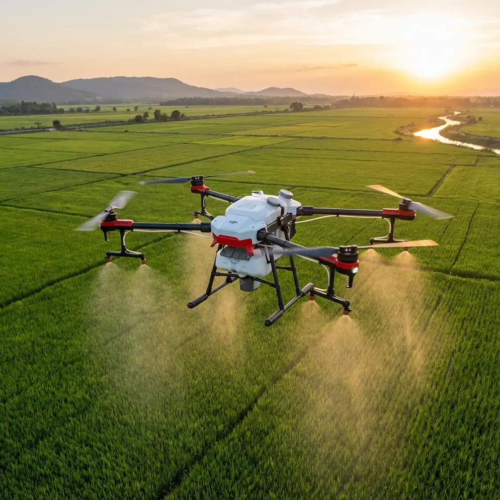
The first thing you notice with Flip is that lift authority feels different in thin air. That does not mean the aircraft suddenly becomes unstable or unmanageable. It means you need to fly with more intention. Vertical punch, braking distance, and responsiveness in gusts all deserve more respect. If your route includes terraces, tree lines, utility runs, lighting rigs, tent edges, or stone walls common in mountain hospitality sites, this becomes an obstacle-management problem, not just a piloting one.
That is where obstacle avoidance stops being a brochure feature and becomes operationally significant. In a venue environment, you are often transitioning from open sky into visually cluttered corridors: over a driveway, between structures, above event furniture, or along the edge of a sloping lawn that drops sharply into open air. Good obstacle sensing gives you a second layer of protection, but it is not a replacement for route design. At altitude, you want smoother, wider lines and earlier corrections because wind can push the aircraft off your intended track faster than you expect.
The second major shift is battery strategy. High-altitude flying often overlaps with cooler temperatures, and that combination changes how conservative you need to be. A battery percentage that feels comfortable at sea level can become a false reassurance when the drone is fighting denser gusts or making repeated climbs above an elevated venue bowl. I found it smarter to build every sortie backward from landing, not forward from the shot list. If the return route involved headwind over exposed terrain, I treated that as the main event, not the outbound leg.
The venue looked calm until it wasn’t
The morning opened clean. Light haze, moderate contrast, a gentle crosswind. The kind of conditions that tempt crews into overconfidence.
I started with broad establishing shots and a few controlled reveals to map the property visually. QuickShots were useful here, not because automation replaces skill, but because they let you capture repeatable movement when the ground team is busy and the window for clean takes is short. For a venue team trying to capture arrivals, exterior context, and social-ready clips in one session, QuickShots can save time as long as you pre-check the airspace around the aircraft and avoid using them in cramped launch zones.
The useful distinction at altitude is this: QuickShots are best treated as pre-visualized motion templates, not one-tap magic. If the venue sits on a ridge, one side of the shot may open into empty air while the opposite side contains trees, cables, canopies, or architectural protrusions. That asymmetry matters. Before running any automated move, I walked the line visually and asked a simple question: if the aircraft drifts five to ten feet off the ideal path due to gusts, what does it meet first?
That discipline paid off later.
By late morning, the weather turned the way mountain weather often does: not dramatically at first, just enough to punish anyone who assumes the previous twenty minutes still describe the next twenty. The wind shifted, temperature dropped, and the soft haze sharpened into uneven contrast. You could see it in the trees before you fully felt it in the controller.
Mid-flight, Flip started doing exactly what you want a well-managed drone to do in deteriorating conditions: it made the changing environment visible through behavior. Small corrections became more frequent. Holding a line over exposed sections required noticeably more effort. The aircraft stayed composed, but the message was clear. Conditions were no longer stable enough for casual creative flying.
That moment is where pilots either gather better footage or make preventable mistakes.
How Flip handled the weather change
The key was not forcing the original shot plan after the air changed. I dropped anything that required long lateral runs over open exposure and shifted to shorter, more protected patterns closer to the structure line of the venue. Obstacle avoidance became more valuable here because wind-driven drift matters more when you are repositioning near built features. Instead of chasing wide heroic arcs, I flew measured segments with cleaner exit options.
ActiveTrack was still usable, but with a stricter standard. In ideal conditions, subject tracking can be a powerful tool for following a person walking a path, a service cart moving into setup position, or a vehicle arrival sequence that benefits from smooth continuity. In shifting mountain wind, ActiveTrack remains useful only if the route is predictable and the environment is readable. Asking it to follow a subject through mixed terrain, near vertical edges, with intermittent visual clutter is poor judgment. Asking it to track someone along a clear, unobstructed path while you maintain generous separation is a different story.
That operational distinction matters because subject tracking is often misunderstood as a convenience feature. In professional venue work, it is more accurately a consistency tool. It helps preserve framing while you focus on airspace, spacing, and fallback options. When weather changes mid-flight, that consistency can reduce workload, but only if you reduce route complexity at the same time.
I used ActiveTrack for one walking sequence after the wind shift, but shortened the path and kept the subject against a clean background instead of the ridgeline. That made the tracking more reliable and the shot more usable. It also reduced the chance that a sudden gust would coincide with the aircraft trying to preserve framing near visual clutter.
Camera choices that matter more at altitude
High-altitude venues produce beautiful light, but also awkward light. You get reflective stone, bright sky, deep shadow under canopies, and terrain that amplifies contrast. If you are shooting for quick delivery, standard profiles can work. If you need footage that survives a serious edit, D-Log gives you more room to manage the harsh transitions common in mountain scenes.
This became especially relevant once the weather changed. The scene moved from soft and forgiving to contrast-heavy in less than an hour. Shooting in D-Log gave me more flexibility to recover highlights along the cloud-bright sky while keeping texture in the darker venue details. For readers delivering to hospitality clients, tourism teams, or event operators, that is not a niche post-production preference. It is the difference between footage that grades cleanly across a changing day and footage that looks like it came from three unrelated shoots.
Hyperlapse also deserves a realistic note here. High-altitude venues can make Hyperlapse look exceptional because clouds, shifting light, and terrain create natural motion layers. But it is one of the first creative modes I become cautious with when wind starts building. Hyperlapse rewards stability, predictable drift correction, and a flight area free of sudden air turbulence. In protected windows, it can add a sense of atmosphere no ground camera can replicate. In unstable conditions, it can become an inefficient use of battery and attention. The smarter move is often to wait for a calmer pocket rather than force a sequence that will not feel smooth in the final edit.
What worked best on the day
Three habits made the difference.
First, I launched with route alternatives already in mind. At a mountain venue, every flight should have a version A, version B, and version stop-now plan. If the wind comes around a structure differently than expected, or cloud cover changes your visibility and contrast, you need a simpler route ready immediately.
Second, I used the venue’s physical layout as protection. Buildings, tree clusters, and slope contours can either create dangerous turbulence or offer brief shelter depending on how the wind is moving. You learn this only by observing the site before trying to shoot it. The instinct to stay high and wide is not always the safest or the most cinematic. Lower, shorter, and more intentional often produces better material when the air gets busy.
Third, I separated “must-have” footage from “nice-if-possible” footage. The must-haves were the establishing passes, arrival coverage, and one reliable tracked movement sequence. The experimental or highly stylized shots could wait. That mindset preserves battery, lowers pilot workload, and protects the essential deliverables.
For teams trying to build a repeatable workflow, I would strongly recommend creating a site-specific communication plan before launch. A simple shared briefing with your ground team—where takeoff is happening, which path will be tracked, what areas are no-go, and what weather trigger ends the flight—saves confusion later. If you need a quick field checklist for that kind of coordination, this direct WhatsApp planning note format is easy to adapt for crews moving between venue zones.
Best practices for delivering at high-altitude venues with Flip
If your actual mission is venue delivery support rather than purely visual capture, the same flight principles become even more critical.
High altitude reduces your performance margin. Wind around structures becomes less predictable. Payload assumptions that feel comfortable at lower elevations may need to be revised downward depending on site exposure and route length. Even if Flip is being used in a mixed role—part site documentation, part light operational support—the discipline is the same: shorter segments, conservative power management, stronger obstacle awareness, and no improvising in deteriorating weather.
Here is the practical version:
Plan routes around safe recovery, not ideal geometry. The straight line is often the worst line if it crosses exposed terrain.
Use obstacle avoidance as a backstop, not a license. It helps when drift or route compression happens, especially near venue infrastructure, but it should never be your main strategy.
Treat ActiveTrack as controlled automation. It is valuable when subject movement is predictable and the background is manageable. It is not a substitute for active risk judgment.
Reserve QuickShots for environments you have already read. They can accelerate content capture, but they still need clearance and wind awareness.
Use D-Log when the venue has mixed light and you expect changing weather. The extra grading latitude matters more in mountain conditions than many pilots expect.
Be selective with Hyperlapse. If the air is unsettled, save the battery and come back when the movement will actually look intentional.
The broader lesson
What impressed me most about flying Flip in this environment was not a single feature. It was how the aircraft’s toolset could be combined intelligently once the conditions stopped being polite.
Obstacle avoidance mattered because the venue was physically complex. ActiveTrack mattered because it reduced workload during controlled movement. QuickShots mattered because setup windows were short. D-Log mattered because the light shifted harder than the forecast suggested. Hyperlapse remained valuable, but only as a choice made at the right time rather than a box to tick.
That is the real story with high-altitude venue work. Success does not come from using every feature. It comes from understanding which feature still makes sense after the weather changes.
And weather does change. On mountains, it always gets a vote.
Ready for your own Flip? Contact our team for expert consultation.