Flip in Complex Terrain: A Field Case Study from a Solar
Flip in Complex Terrain: A Field Case Study from a Solar Farm Shoot
META: A real-world case study on using Flip to film solar farms in difficult terrain, covering obstacle avoidance, ActiveTrack, D-Log, Hyperlapse, and mid-flight weather changes.
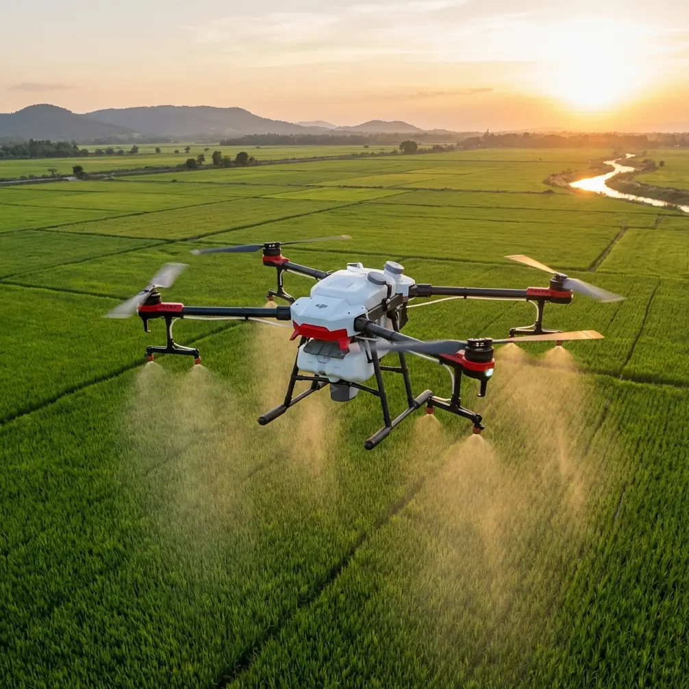
Solar farms rarely sit on flat, forgiving ground.
On paper, they look orderly: long rows of panels, repeatable geometry, clean access lanes. In the field, that neatness breaks apart. Sites often spill across uneven grades, drainage cuts, service roads, fence lines, scrub growth, and low ridgelines that distort wind in ways you only notice once the aircraft is already working. For a photographer, that creates a very specific challenge. You are not just trying to capture scale. You are trying to make a large industrial asset readable on screen without flattening the terrain that explains why the site was built the way it was.
That was the assignment I had in mind when I took Flip out to film a solar installation spread across rolling ground with changing elevation and narrow maintenance corridors. The brief sounded simple enough: show the layout, show the terrain, and get footage that could work both for documentation and for a polished short edit. The reality was more demanding. This was not a location where you could push a drone in a straight line and expect useful footage to fall out.
What made Flip interesting on this job was not one headline feature. It was how several of its flight and imaging tools fit together when conditions started shifting.
The site itself forced the issue immediately. Rows of panels created long reflective surfaces with repetitive visual patterns, while the surrounding terrain introduced abrupt elevation changes. That combination can be surprisingly awkward. Repeating geometry tends to expose sloppy framing, and uneven ground punishes pilots who are too focused on composition to maintain safe spacing. On a solar farm, the drone has to read both the macro and the micro: broad site layout from above, then lower passes that preserve depth without drifting into structures, fencing, or utility hardware.
This is where obstacle avoidance stopped being a spec-sheet talking point and became operationally significant. Flying low along panel rows is useful because it gives viewers a sense of scale and rhythm, but it also narrows your margin for error. The practical value of obstacle sensing in that environment is not just collision prevention in the abstract. It lets you maintain cleaner, more confident motion while your attention is split between airspace, framing, and changing ground clearance. On this shoot, that mattered most when transitioning from a higher establishing angle down into service-lane passes where the terrain dipped faster than it looked from the takeoff point.
I used ActiveTrack selectively rather than as a crutch. That distinction matters. Solar farms are not moving subjects in the conventional sense, but maintenance vehicles and inspection buggies often are. One sequence involved tracking a utility vehicle moving between rows to give the site some human scale and operational context. In open terrain, subject tracking can be routine. In this environment, with repetitive panel patterns and intermittent obstructions, the real benefit was continuity. ActiveTrack helped hold a usable framing relationship while I concentrated on route and altitude management through a corridor that visually compressed more than expected. The result felt less like a “follow mode” gimmick and more like a controlled production tool.
QuickShots were less central to the final film, but still useful during the location pass. I often treat those automated patterns as previsualization tools rather than finished assets. At a site like this, where you need to understand how geometry reads from different heights and arcs, a fast orbit or pull-away can reveal whether the array looks legible or just repetitive. That is an underrated use case. Not every automated move belongs in the final cut, but some of them tell you very quickly what the location wants from the camera.
The strongest footage of the day came later, after the weather shifted.
The forecast had suggested stable conditions for the main shooting window. That turned out to be optimistic. About halfway through the session, the light hardened, the wind changed direction, and a bank of clouds started pushing across the site. This is where a lot of drone shoots quietly fall apart. Not because the aircraft cannot remain airborne, but because the image stops matching itself. One pass is warm and open. Ten minutes later, the contrast spikes, reflections sharpen on the panels, and the terrain loses detail in the shadows. If you are building a sequence meant to feel continuous, those changes can wreck the edit.
Flip handled that transition better than expected, partly because of flight stability and partly because of capture flexibility. The wind was not extreme, but it was enough to start tugging at lateral moves over exposed ground. What I needed was not heroics. I needed the drone to stay composed enough that I could preserve planned motion paths without every shot turning into a correction exercise. In practical terms, that meant cleaner repeat passes and less wasted battery time trying to match an earlier line.
The imaging side mattered just as much. Shooting in D-Log gave me room to absorb the weather swing in post rather than letting the scene bake in its inconsistency. On reflective infrastructure, especially solar panels, tonal control is not a luxury. You are balancing highlights off glass-like surfaces against darker service roads, vegetation, and under-panel shadow. When the sun kept disappearing behind passing cloud and then reappearing, the flatter capture profile protected detail that would have been harder to recover in a more baked-in look. That gave me a workable path to unify sequences captured before and after the change.
Operationally, this is one of the most useful things about pairing a stable flight platform with log capture. It is not about chasing a cinematic label. It is about keeping an edit coherent when the environment stops cooperating.
I also leaned on Hyperlapse for one sequence that ended up carrying more narrative weight than I expected. Solar projects are massive by design, but static wide shots can make them feel inert. A well-planned Hyperlapse over changing light solved that problem. Instead of treating the installation as a giant still object, the sequence showed the site as a system embedded in landscape and weather. Clouds advancing over the panel field, shadows stretching across the rows, terrain contours revealing themselves through light shifts—those changes communicated scale better than another conventional aerial reveal would have.
That sequence only worked because the route was chosen carefully. Hyperlapse over complex terrain can expose every inconsistency in altitude control and framing, so the path had to avoid awkward foreground intrusions while maintaining enough parallax to show the site’s contours. Again, obstacle awareness was not a background feature. It influenced what routes were practical to fly safely and repeatedly.
One of the less obvious challenges with filming solar infrastructure is visual monotony. If every shot simply confirms that there are many rows of panels, the audience stops seeing the site after ten seconds. The terrain is what rescues the story. You need low passes that reveal gradient, oblique angles that show drainage and spacing, and movement patterns that connect the installation to the land around it. Flip’s value on this kind of assignment is that it supports those transitions without making you choose between safety and visual intent every few seconds.
There is also a production efficiency angle here that deserves attention. On a location with complex terrain, battery time disappears fast if the aircraft or workflow fights you. Repeated resets, abandoned approaches, and mismatched exposure between takes are not minor annoyances; they directly reduce the number of useful sequences you bring home. The combination of obstacle avoidance, dependable subject tracking, and flexible color capture reduced that friction. Not perfectly, because no field workflow is perfect, but enough to change the output. That is a meaningful distinction for anyone filming infrastructure where access windows, weather, and site operations may all compress the schedule.
If I were advising another photographer heading into a similar solar farm job with Flip, I would focus less on dramatic maneuvers and more on shot architecture.
Start with a high establishing pass to map the site’s logic. Then drop into medium-height lateral shots that show the rows interacting with topography. Use ActiveTrack only when a moving subject genuinely helps explain the site, such as a service vehicle or inspection team. Reserve QuickShots for scouting composition or for brief transitions, not as the backbone of the project. If weather is unstable, capture your anchor sequences in D-Log so you can preserve continuity later. And if the cloud movement becomes visually interesting, use Hyperlapse to turn a scheduling problem into part of the story.
That last point is worth underlining. Weather changed the assignment mid-flight, but it improved the final piece because Flip allowed me to adapt instead of retreating into safe, generic coverage. The site became more legible once the light started shifting across it. The rolling terrain showed up more clearly. The reflective surfaces gained variation. The atmosphere introduced movement that the infrastructure itself does not provide.
For crews that document large energy assets, this is often the difference between technically correct footage and footage that actually explains something. A solar farm is not just an arrangement of hardware. It is an engineered response to land, light, access, and scale. A drone should help make that visible.
Flip did that best when I stopped thinking about features in isolation. Obstacle avoidance made lower, terrain-sensitive routes practical. ActiveTrack stabilized a moving-subject sequence that could easily have turned messy in a corridor of repeating structures. D-Log preserved editorial flexibility when cloud and sun kept trading places. Hyperlapse translated a weather disruption into a sequence with narrative value. Even QuickShots earned a place by accelerating location decisions early in the session.
That combination is what made the day productive.
If you are filming solar farms in broken terrain, the real test is not whether a drone can capture a dramatic reveal. Most can, under ideal conditions. The real test is whether it helps you keep shape, safety, and visual consistency when the ground is uneven, the rows are repetitive, and the weather stops following the schedule. On this shoot, Flip passed that test in a way that felt practical rather than theatrical.
If you want to compare notes on workflows for similar sites, I’ve found that a quick message often saves more time than another round of trial and error—reach me here: https://wa.me/example
Ready for your own Flip? Contact our team for expert consultation.