Inspecting Remote Coastlines with Flip: Sensor Discipline
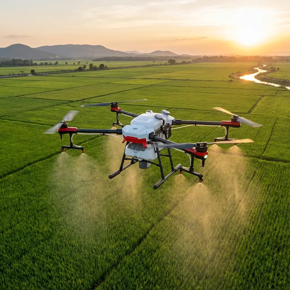
Inspecting Remote Coastlines with Flip: Sensor Discipline, Stable Altitude, and Cleaner Results
META: A practical Flip tutorial for remote coastline inspection, focused on altitude stability, IMU and barometer behavior, EMI handling, obstacle avoidance, and capture settings for reliable field results.
Remote coastline work looks simple from a distance. Launch, fly the edge, capture the rock face, check erosion, document structures, head home. In reality, the hard part is consistency. Wind shifts. Salt haze softens contrast. Uneven terrain and cliff edges complicate altitude control. And when you are working far from easy recovery points, small sensor errors become operational problems fast.
That is where a more disciplined way of flying Flip matters.
This tutorial is built around one technical point that deserves more attention in field practice: height estimation is never just about one sensor. The reference material behind this piece discusses a tightly coupled IMU and barometric altimeter approach, and that matters directly to remote coastal inspection. If you want repeatable passes along cliffs, sea walls, tidal inlets, or exposed shoreline assets, you need to understand how motion, sensor bias, and orientation errors shape the aircraft’s vertical behavior.
I shoot as a photographer first, but on coastline jobs I think like an inspector. Pretty footage is useful. Reliable geometry and stable altitude are what make the mission worth repeating.
Why coastline inspection punishes sloppy altitude control
Over open water and broken shoreline, visual cues can be deceptive. You may think the aircraft is holding clean height because the horizon looks calm on screen, yet the drone is working through a stack of corrections underneath. A barometric reading may drift. The IMU may be compensating for pitch changes in gusts. If the aircraft experiences strong horizontal acceleration, the vertical estimate can become less trustworthy if orientation is even slightly off.
That relationship comes straight out of the source material. One of its key findings is that small inclination errors only have a moderate effect on computed vertical acceleration under normal conditions, but in the presence of large horizontal acceleration, even a small orientation error can create a sizable vertical acceleration error. In plain field language: if Flip gets shoved sideways by coastal wind, bad attitude estimation can show up as unstable height behavior at exactly the moment you need precision.
This is why aggressive stick inputs are usually the wrong move near cliffs. Smooth control gives the onboard estimation system less to untangle.
The practical sensor stack: IMU plus barometer
The source also highlights a tightly coupled system using an IMU and barometric altimeter, with key parameters estimated together. Operationally, that is more significant than it sounds.
The IMU helps the aircraft understand motion and orientation. The barometric altimeter contributes change in height based on air pressure variation. Each has weaknesses on its own. The IMU can accumulate error and is sensitive to bias. The barometer can be influenced by environmental pressure changes and local conditions. Together, they provide a more useful estimate than either would alone.
For coastal inspection, this pairing helps with three things:
Maintaining repeatable standoff distance from terrain
If you are documenting a rock wall or revetment on multiple passes, stable relative height improves comparability between clips and stills.Keeping image sequences cleaner for mapping or visual review
Sudden altitude bobbing creates inconsistent overlap and perspective. Even if your goal is a visual inspection rather than full mapping, cleaner altitude behavior makes defects easier to track across frames.Reducing pilot workload in isolated locations
In remote areas, you do not want to spend the whole mission fighting vertical drift manually. Better sensor fusion means more attention available for composition, safety, and route discipline.
The overlooked problem: accelerometer bias
One detail from the reference is especially useful for real-world operators: the projection of the accelerometer bias vector on the vertical is directly proportional to the magnitude of the bias vector. That means a small sensor bias can directly contaminate height estimation.
The source gives a concrete figure: an accelerometer with bias instability of 1 mg can still produce meaningful error growth over time. You do not need to be doing advanced autonomy work for that to matter. During a long coastline pass, tiny sensor imperfections can reveal themselves as subtle altitude inconsistency, especially if the aircraft is repeatedly correcting against wind and turbulence.
What should a Flip operator do with that information?
Not panic. Calibrate intelligently and fly in a way that reduces stress on the estimation chain.
Pre-flight routine for remote coastlines
Before any remote shoreline mission, I use a tighter checklist than I would for casual landscape shooting.
1) Start from a magnetically clean setup area
Your context note mentions handling electromagnetic interference with antenna adjustment, and that is not just a convenience issue. EMI can confuse the aircraft environment and the pilot’s confidence at the same time. Avoid launching beside metal railings, parked utility vehicles, heavy concrete reinforcement, or large powered equipment near harbors and coastal infrastructure.
If you see interference warnings or unstable signal behavior, do not just accept it as “coastline noise.” Step away from the source and re-orient your controller antennas deliberately. Antenna faces should be aligned for the strongest link to the aircraft rather than pointed carelessly at it. A cleaner link reduces command hesitation and improves confidence during low-margin sections of the route.
If you need a second opinion from an experienced team before planning a remote shoreline workflow, I’d use this direct WhatsApp line: ask a Flip specialist.
2) Let the aircraft settle before the first inspection pass
After takeoff, hover briefly in a safe open area. Watch for unnecessary vertical pulsing, odd drift, or attitude corrections. This is less about superstition and more about giving yourself a quick read on the sensor state before committing to a cliff-adjacent route.
3) Use conservative stick inputs at the start
The source material’s warning about horizontal acceleration is worth turning into a habit. Do not hammer the controls as soon as you lift. Fast lateral bursts can magnify the consequences of slight orientation errors in vertical estimation. Build speed gradually.
4) Verify your return path over land if possible
Remote coasts often create awkward recovery geometry. If you can position yourself so the return leg offers a more forgiving route over stable ground rather than over surf or jagged rock, do it.
Flight technique: how to get cleaner inspection data with Flip
A lot of pilots over-focus on headline features and underuse them in disciplined ways. Flip’s smart functions can help, but only when the mission comes first.
Obstacle avoidance is not a substitute for route planning
On a coastline, obstacle avoidance is useful around protruding rocks, signs, sparse utility structures, and abrupt terrain transitions. But sea spray, low contrast surfaces, and irregular edges can confuse any visual system. Use obstacle avoidance as a safety layer, not as your primary strategy.
I prefer to pre-visualize three distances:
- legal and safe offset from the coastline
- minimum acceptable clearance from protrusions
- image-effective distance for the sensor and lens
That way, obstacle avoidance is there to catch surprises rather than to design the whole flight in real time.
ActiveTrack and subject tracking need a commercial mindset
If your target is a moving vessel in a civilian inspection context, a shoreline survey vehicle, or a person conducting a site walk, subject tracking can save effort. But for static infrastructure and erosion work, automated tracking can produce unnecessary path variations. I use ActiveTrack selectively, mostly when documenting a moving maintenance operation rather than the coastline itself.
Consistency beats novelty in inspection footage.
QuickShots are rarely the main event, but they have one use
For pure inspection, QuickShots are usually secondary. Yet a controlled reveal shot can be valuable at the beginning of a report sequence, especially to show how a damaged section relates to the broader shoreline. Use it once, then move back into measured passes.
Hyperlapse can support environmental storytelling
When your client or stakeholder needs to understand tidal movement, surf impact, or changing human activity around a site, Hyperlapse can add context. It is not a substitute for direct inspection imagery, but it can help explain why a particular stretch of coast experiences repeated wear.
Camera setup: image choices that help later review
As a photographer, I care about flexibility in post, but coastline inspection is not only about aesthetics.
D-Log for difficult light
Remote shorelines often produce brutal contrast: bright water, dark rock, reflective wet surfaces, and haze. D-Log can preserve more tonal information, which helps if you need to recover detail in both the surf line and shadowed cliff texture. That is particularly useful when later review may depend on subtle surface changes rather than dramatic visuals.
Slow and level beats dramatic every time
A flat, stable pass is more valuable than a cinematic swoop when the goal is inspection. If I need a hero shot, I separate that from the data capture pass. Mixing both objectives in one line usually weakens both.
Repeat path, repeat altitude, repeat angle
If the mission may be revisited after storms or seasonal change, fly with replication in mind. Matching your previous route and camera angle is easier when your altitude behavior is stable, which brings us back to why the IMU-barometer relationship matters.
Reading bad behavior in the air
Some warning signs are subtle. Here is what I watch for during remote coastal work:
- small but persistent altitude bobbing during lateral flight
- abrupt correction after gusts
- video that suggests uneven vertical spacing relative to a cliff face
- inconsistent framing on a route that should be easy to repeat
- signal uncertainty that improves only after controller or antenna repositioning
These do not automatically indicate a major fault. Often they reflect a mix of wind, sensor estimation limits, and environmental interference. But if they stack up, shorten the mission and reset rather than pushing through.
Why heading errors matter less than you might think here
Another useful point in the source is that heading errors have no adverse effect for height estimation. That is a technical detail with practical reassurance. During a shoreline pass, your biggest concern for vertical reliability is not usually yaw disagreement by itself. It is the combination of acceleration, orientation accuracy, and sensor bias affecting altitude interpretation.
That helps prioritize pilot attention. If the aircraft is holding framing but struggling with height consistency in gusts, look first at motion smoothness, calibration status, and environmental conditions before assuming every issue is a heading problem.
A sample coastline workflow with Flip
Here is the field sequence I would use for a remote inspection mission:
Phase 1: Establish
Launch from a clean area away from obvious EMI sources. Check signal quality. Adjust antennas for a strong controller-aircraft link. Hover and observe for stable hold.
Phase 2: Recon pass
Fly a higher, safer line parallel to the coastline. Identify protrusions, birds, cables, spray zones, and any false visual cues created by rock texture or foam.
Phase 3: Primary inspection pass
Descend to your planned working height and keep speed moderate. Use smooth lateral motion. Let obstacle avoidance remain active, but do not rely on it to decide spacing. Capture in D-Log if lighting is harsh.
Phase 4: Detail collection
Stop at pre-identified features such as cracks, undercut sections, damaged barriers, or drainage outlets. Use controlled hover shots and short lateral shifts rather than circular wandering.
Phase 5: Context sequence
If needed, add one wider pass, a restrained QuickShot, or a short Hyperlapse to show environmental context.
Phase 6: Exit early, not late
Remote coastline jobs punish overconfidence. End with battery and recovery margin intact.
The real lesson from the reference material
The source is technical, but the field takeaway is straightforward. Reliable height behavior depends on more than a nominally good drone. It depends on sensor fusion, on how accelerometer bias projects into the vertical channel, and on whether the pilot creates flight conditions that help or hurt the estimation system.
That is especially relevant with Flip in remote coastal inspection, where wind-driven lateral acceleration, uneven terrain, and limited recovery options all raise the cost of sloppy technique.
Fly smoothly. Respect sensor behavior. Treat EMI as a practical problem, not a background annoyance. Use smart features selectively. And remember that the most useful inspection footage is not always the most dramatic. It is the footage you can trust on the second review, the fifth comparison, and the next site visit.
Ready for your own Flip? Contact our team for expert consultation.