Flip Best Practices for Urban Field Inspection: A Sensor
Flip Best Practices for Urban Field Inspection: A Sensor-Fusion Case Study
META: A practical case study on using Flip for urban field inspection, with expert guidance on altitude stability, pre-flight cleaning, obstacle avoidance, and why barometric drift matters.
Urban field inspection sounds simple until altitude starts lying to you.
I see this most often in edge-of-city environments: sports grounds hemmed in by buildings, research plots near roads, utility corridors passing through mixed-use districts, and landscaped commercial properties where you need clean visual documentation without wasting time on repeated passes. In these places, the drone’s camera matters, but altitude behavior matters just as much. If your aircraft slowly creeps up or down in its internal estimate, framing shifts, overlap changes, and repeatability suffers.
That is why a surprisingly technical point from a hexacopter design study is useful when thinking about Flip in real inspection work. The paper, from Harbin Institute of Technology, focused on height measurement and sensor fusion. Its value here is practical: it explains why altitude control is never just about one sensor, and why operators who understand that tend to get more consistent inspection results.
This case study looks at Flip through that lens.
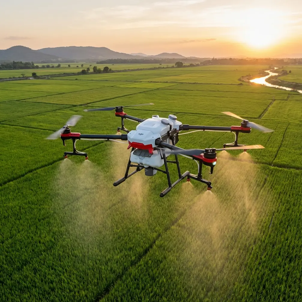
The urban inspection scenario
Picture a morning inspection of several narrow agricultural test fields inside an urban fringe zone. There are fences, lamp posts, small trees, rooftop turbulence from nearby buildings, and limited takeoff space. The job is civilian and visual: document crop condition, edge encroachment, drainage patterns, and general site changes for a property manager and an agronomy consultant.
Flip is a natural fit for this kind of mission because it can move quickly from overview capture to tighter visual passes. Features like obstacle avoidance and subject-aware automation can help reduce workload in cluttered spaces, while QuickShots, Hyperlapse, D-Log, and ActiveTrack all expand what kind of deliverables a photographer or inspector can produce. But those features only deliver useful results if the aircraft is sensing the environment correctly.
That begins before takeoff.
The pre-flight cleaning step most people rush
If I am flying in an urban field setting, I do one basic thing before powering up: I clean the forward, downward, and side-facing sensing areas and check for dust, moisture film, or fingerprint smearing.
This is not cosmetic. It is a safety step.
Obstacle avoidance performance depends on clean sensing surfaces. A thin smear can reduce contrast, and urban sites are full of visual clutter that already makes interpretation harder: chain-link fencing, reflective windows, thin branches, repetitive lines in crop rows, and hard shadow boundaries. If you plan to use ActiveTrack for slow moving inspection sequences or automated cinematic passes for documentation, sensor confidence matters. A dirty sensor window is a quiet way to degrade it.
I also check the body vents and the area around pressure-related openings. Even when the aircraft’s software does an excellent job blending sensor inputs, contaminated or obstructed sensing hardware can contribute to unstable behavior over the length of a job, especially when you are chasing repeatable height and smooth motion.
It is the kind of step experienced operators do without making a speech about it. And it pays off.
What the reference study gets right about altitude
The source material highlights a problem every inspection pilot eventually encounters: barometric altitude is useful, but imperfect.
One detail stands out immediately. The study notes that unstable weather and atmospheric pressure fluctuations can lead to altitude drift of several meters per hour. That may sound small if you are flying a short recreational sortie. It is not small when you are documenting the same field across multiple passes or revisiting a site over a long morning.
Several meters of drift changes perspective. It alters apparent plant density in oblique shots, shifts sightlines over fences, and changes how roof edges or trees interact with the background. If you are trying to compare images over time, that inconsistency can become a hidden source of bad interpretation.
The study also states that a stationary reference barometer can be used to monitor pressure fluctuations so relative height changes can be measured more effectively over longer periods. Operationally, that is a powerful idea even if your workflow is much simpler than a research setup. The lesson is this: altitude confidence improves when you stop trusting any single input blindly.
For a Flip operator inspecting urban fields, that translates into a better habit set:
- verify takeoff point consistency
- avoid unnecessary long hover periods before capture runs
- use strong visual references in the scene
- cross-check altitude behavior with what you actually see in frame
- break long jobs into shorter repeatable segments if environmental conditions are shifting
These are field decisions, not laboratory theory. But they come from the same truth the paper is dealing with.
Why vertical acceleration alone is not enough
The reference also discusses a state equation where vertical acceleration is integrated into position, with a two-state Kalman approach using height and velocity. In plain terms, this is about combining motion sensing with height sensing rather than pretending one can replace the other.
That matters because acceleration is noisy, and noise compounds when you integrate it over time. The study used a sampling period of 0.005 seconds and specifically warned that accelerometer bias estimation and compensation are important. That is the operational significance. Tiny bias errors become larger position errors if they are allowed to accumulate.
For an urban inspection flight, this shows up in a familiar way: a drone may feel fine at first, then gradually stop holding the exact vertical attitude you expect during pauses, orbit-like moves, or low-speed cinematic tracking. It may still be safe to fly, but it becomes less precise for documentation.
The same source gives another concrete number: the barometer signal was modeled with zero-mean white noise having a standard deviation of about 1 meter, while the accelerometer noise was given as 0.008 m/s². Even without diving into the math, you can see the tradeoff. The barometer is noisy but stabilizing over time; the accelerometer reacts quickly but drifts if bias is not handled well.
This is why modern flight behavior feels intelligent when it works well. The aircraft is not “using altitude.” It is negotiating between imperfect views of altitude.
As an operator, you should fly with that in mind.
Applying that to Flip in a real inspection run
On a recent-style urban field workflow, I would divide the mission into three capture layers.
1. Establishing overview
Start with a conservative, stable pass that maps the site visually rather than aggressively chasing detail. This is where obstacle avoidance earns its keep. In urban fringe spaces, the biggest threats are rarely dramatic. They are poles, wires near vegetation, overhanging branches, and abrupt spatial compression near walls or fencing.
At this stage, I want Flip to give me context shots with clean geometry. If I am shooting for a client who may request grading or post work, D-Log is useful because it preserves flexibility in scenes with bright sky and dark urban edges. You do not need every shot in a flat profile, but for mixed-contrast environments it can save a lot of detail.
2. Repeatable medium-height inspection passes
This is where the barometric drift lesson becomes real. I keep each pass short and purposeful. Instead of hovering endlessly while deciding what to do next, I reset mentally at each segment. If the aircraft has been in the air a while and weather is shifting, I do not assume that indicated altitude still means what it did ten minutes earlier.
The reference paper’s point about several meters per hour of potential drift is exactly why this matters. In a long urban inspection, your framing can slowly become less comparable even if your route feels consistent.
Using visible landmarks helps. Fence tops, path edges, irrigation lines, or known roof heights can act as practical confirmation that your flight layer is staying where you want it.
3. Close visual storytelling and evidence capture
Here Flip’s creative tools become more than “content features.” QuickShots and Hyperlapse can be useful in inspection reporting if used carefully. A controlled reveal of drainage direction, access limitations, or vegetation encroachment can communicate site conditions faster than a folder full of disconnected stills.
ActiveTrack also has a place when documenting a walking surveyor, grounds manager, or technician moving along a boundary line. In cluttered urban environments, though, I use it conservatively. Tracking should support the inspection, not become the inspection. Sensor cleanliness and route awareness matter more here than feature enthusiasm.
The hidden value of averaging and patience
One underappreciated detail in the source is the note that to obtain roughly 0.1 meter altitude precision from barometer information alone, several seconds of averaging would be needed. That tells you two things.
First, instant readings are not sacred. Second, patience can improve reliability.
In practical Flip use, that means if you need a particularly careful altitude-sensitive shot, it often helps to let the aircraft settle briefly rather than immediately forcing a complex move after every directional change. Not a long idle. Just enough time for the system to stabilize before the critical capture.
This is especially helpful near urban obstacles where air movement can be messy. Building edges create uneven flow, and open plots next to structures are famous for producing misleadingly calm takeoff impressions followed by twitchier behavior higher up.
The drone may be capable of very fluid motion, but disciplined timing still improves outcomes.
What the Xsens and tactical-grade IMU detail tells us
The study’s first experiment physically paired an Xsens MTi-G sensor with a tactical-grade IMU to evaluate performance. You do not need that hardware stack to appreciate the lesson. The significance is that serious altitude evaluation is done through comparison, not faith.
That mindset is useful for any Flip operator doing urban field inspection:
- compare what telemetry says with what the frame shows
- compare one pass with the next
- compare launch-point assumptions with actual scene geometry
- compare autonomous behavior with your own visual judgment
Good operators are always validating. They are not just flying.
If you ever feel the aircraft’s vertical behavior is slightly off, do not push through because the mission is “almost done.” Land, inspect the sensors, confirm environmental conditions, and restart if needed. A few extra minutes on the ground beats discovering later that the best segment of the job is not repeatable.
A photographer’s perspective on technical discipline
As a photographer, I care about this because bad altitude consistency ruins visual credibility long before it causes obvious flight trouble.
When images of the same field are captured from slightly drifting heights, the viewer often cannot explain why the set feels inconsistent. But they feel it. Horizon relationships shift. Plant rows look denser or thinner. Structures in the background loom differently. Shadows cut across the frame at a different proportion. The report becomes harder to trust.
That is why technical discipline and visual storytelling are not separate jobs. They are the same job.
Flip can absolutely serve urban field inspection well, especially when you need a compact workflow that handles both safe navigation and polished output. But the best results come from operators who understand the sensor logic beneath the convenience. Clean the sensing surfaces. Watch the environment. Respect altitude drift. Use automation as an assistant, not a substitute for judgment.
If you are planning a workflow and want a practical conversation about setup choices, field habits, or feature use in dense civilian environments, you can message a local drone specialist here.
The real takeaway
The most useful thing in the reference material is not the equation. It is the reminder that height is inferred, corrected, filtered, and constantly negotiated between noisy sensors.
For urban field inspection with Flip, that has direct consequences:
- pre-flight cleanliness affects obstacle sensing confidence
- pressure changes can slowly distort altitude consistency over time
- accelerometer bias, if left unchecked by the system, can accumulate into position error
- shorter, deliberate passes are often better than one long casual mission
- visual confirmation in the scene remains essential even when smart features are available
That is what separates a clean inspection dataset from a merely pleasant flight.
Ready for your own Flip? Contact our team for expert consultation.