Mapping Solar Farms at High Altitude With Flip: Safety
Mapping Solar Farms at High Altitude With Flip: Safety, Signal Discipline, and Smarter Pre-Flight Habits
META: A field-tested guide to using Flip for high-altitude solar farm mapping, with practical insight on obstacle sensing, pre-flight cleaning, flight safety, and why disciplined setup matters as drone traffic grows.
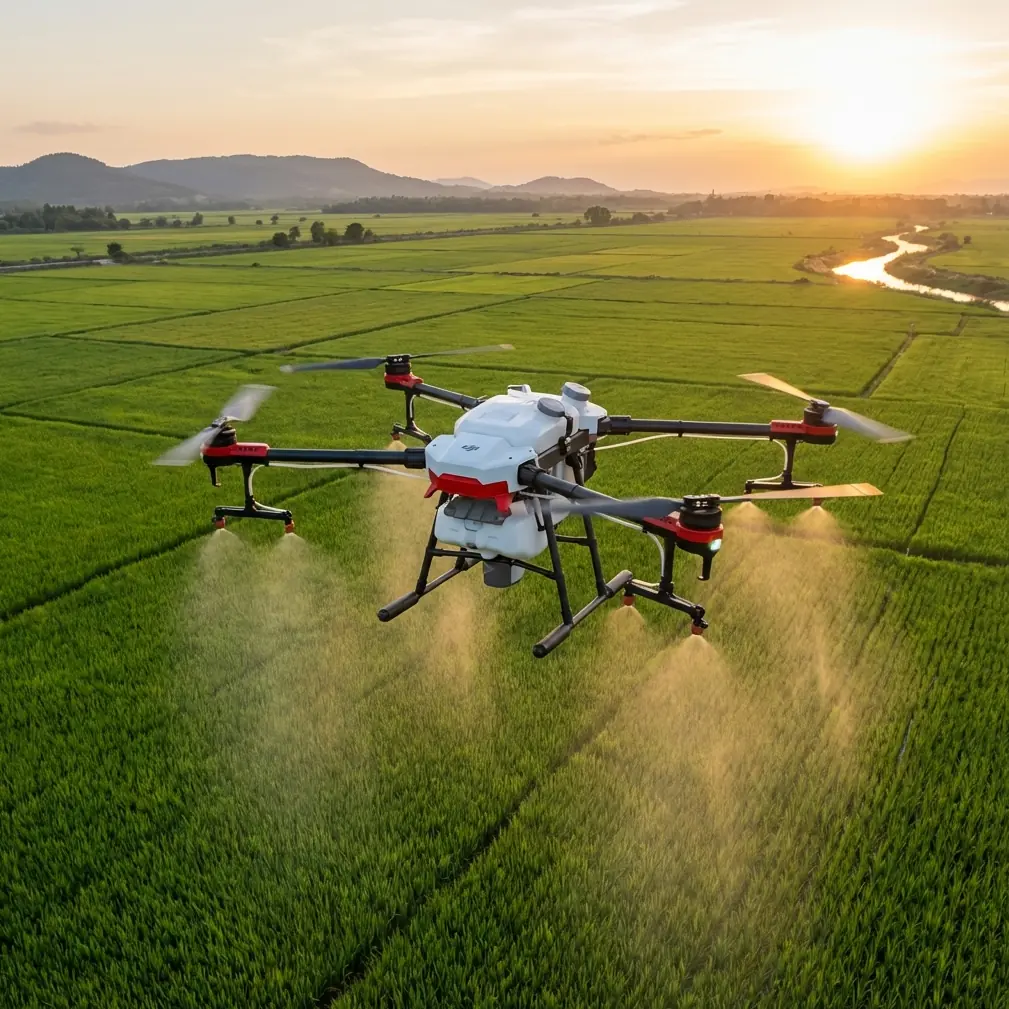
High-altitude solar sites are deceptive places to fly.
From the ground, they often look open, repetitive, and forgiving—long rows of panels, access roads, inverter stations, perimeter fencing, maybe a few utility poles. In the air, the reality changes. Glare can confuse your visual read of distance. Wind behaves differently as it spills over ridgelines. Thin air can alter the feel of the aircraft, especially during repeated mapping runs. And because solar farms are built around precision, your drone work has to match that standard.
That is where a platform like Flip becomes interesting.
Not because it magically removes field risk. It does not. What it can do—when used with discipline—is reduce friction in the workflow of site documentation, visual inspection support, and repeatable aerial capture. For teams mapping solar farms at elevation, the real question is not whether a drone can fly the mission. It is whether the flight data will be reliable, the operation safe, and the output consistent enough to support decisions on asset condition, layout verification, and reporting.
Those are different standards entirely.
The real problem is not just flight. It is density.
Drone safety became a mainstream issue for a reason: there are simply far more aircraft in circulation than there used to be. What was once a niche tool, largely associated with wealthy hobbyists and specialized institutions, turned into a mass-market device category. That shift matters operationally. By 2016, the FAA had already reported around 600,000 drones registered or otherwise recorded in the United States. That figure is old now, but it marks the moment when drone operations stopped being a novelty and became an environment management problem.
For a solar mapping crew, that broader context matters in two ways.
First, it means safe operation is no longer about your aircraft alone. It is about operating in a world where drones are common, expected, and increasingly scrutinized. Site managers, insurers, project owners, and EPC partners want procedures, not improvisation.
Second, it explains why attention has grown around systems designed to detect, intercept, or capture unauthorized drones. Even if your work is entirely legitimate and commercial, the rise of counter-drone thinking has changed the atmosphere around flight operations. On large infrastructure sites, professionalism is no longer optional. Clear permissions, visible crew conduct, accurate flight planning, and predictable aircraft behavior help distinguish a mapping mission from an unwanted intrusion.
That is especially true at remote energy sites, where security staff may be alert to anything airborne.
Why high-altitude solar farms expose weak habits
A drone can perform beautifully in a parking lot test and still become unreliable on a mountain solar site.
High-altitude environments exaggerate sloppy preparation. Dust accumulates faster than many operators realize, especially around unpaved service roads. Temperature swings between morning and midday can affect batteries and lens clarity. Harsh sun angles create false confidence: you think you can see everything, but reflective panel surfaces conceal obstacles and distort orientation.
With Flip, that puts extra pressure on the features people often take for granted—particularly obstacle avoidance and camera-based scene awareness.
These systems only help if they can see cleanly.
That leads to one of the most overlooked safety habits in commercial drone work: a deliberate pre-flight cleaning step. Not a casual wipe with a shirt cuff. A real inspection and cleaning routine for the camera glass, sensing windows, and airframe surfaces that can collect fine grit. On a solar farm, airborne dust and pollen can settle on forward-facing sensors before the second sortie of the day. At altitude, where the pilot may already be managing wind and line-of-sight complexity, degraded sensor performance is exactly the kind of subtle issue that turns into a preventable near miss.
If Flip is being used with obstacle sensing engaged, dirty sensor surfaces can reduce the value of one of its most practical safeguards. Operationally, that means your pre-flight workflow should treat cleaning as part of flight readiness, not cosmetic maintenance.
Flip’s value in solar mapping is about control, not novelty
People often discuss drone features in isolation: subject tracking here, cinematic modes there, color profiles somewhere else. That is fine for consumer comparison pages. It is not how real site work feels.
In a solar farm mapping scenario, the useful question is how those capabilities support a smoother chain from launch to deliverable.
Take ActiveTrack and broader subject tracking functions. A solar site is not a sports scene, and tracking is not the first feature most mapping crews think about. Yet there are field cases where it becomes useful: documenting a maintenance vehicle route through a site, following a technician convoy between array blocks for progress visuals, or creating training footage that shows safe movement paths around infrastructure. Used carefully, tracking reduces the pilot workload associated with maintaining framing while also watching terrain and site geometry.
The significance is not cinematic polish. It is repeatability. If your documentation package includes operational footage for internal review, training, or stakeholder communication, a controlled tracking mode can produce cleaner, more consistent clips than manual follow attempts.
Then there is D-Log. On paper, this sounds like a feature for content creators. In practice, for solar environments, it can be a practical asset. High-altitude sunlight is hard and unforgiving, and solar panels create brutal contrast between bright reflections and dark structural components. A flatter capture profile preserves more flexibility for balancing those extremes in post-production. If you are producing visual records that need to reveal condition issues near frames, cable runs, combiner boxes, or access lanes, dynamic range matters. It may not replace dedicated thermal or survey workflows, but it improves the value of standard visual footage.
Hyperlapse and QuickShots sit in a different category. They are not primary mapping tools, but dismissing them would be shortsighted. For project documentation, stakeholder updates, and construction-phase communication, these modes can compress site-scale change into a format people actually watch. A Hyperlapse sequence from dawn to active maintenance hours can show traffic patterns, shadow movement, or workflow bottlenecks in a way static reports cannot. QuickShots, when used conservatively and safely, can help produce briefing visuals for non-technical audiences who need a site overview without sorting through raw flight logs.
The point is not that Flip turns infrastructure work into a media production. It is that the platform’s so-called creative tools can serve operational communication when used with discipline.
The biggest mistake on mountain solar sites: assuming “open space” means low risk
Solar farms look spacious. They are not simple.
Perimeter fences, weather stations, cable trenches, poles, substation edges, parked service vehicles, and abrupt elevation changes create a clutter map that shifts with every maintenance cycle. Add gusty wind and strong reflected light from panel fields, and your margins shrink quickly.
This is where obstacle avoidance earns its keep—but only if the pilot understands its limitations. Sensing aids are not a substitute for route design. They are a layer of protection around a fundamentally manual responsibility: choosing safe transit paths, conservative altitudes, and realistic turnaround points.
For high-altitude mapping, my preference is to think of Flip in zones.
- Transit zone: The route from launch point to the work area should be the simplest part of the mission.
- Capture zone: This is where panel geometry, reflected light, and site structures demand the most attention.
- Recovery zone: The final return path deserves its own planning, especially if afternoon winds have built since takeoff.
That structure sounds basic. It is basic. But it prevents the most common type of field sloppiness: treating the whole site as one continuous, loosely managed airspace.
A clean obstacle sensing system, a rehearsed route, and a clear visual understanding of each zone create a much more dependable operation than any one feature alone.
Why professionalism matters more now than when drones were niche
The older drone era had a certain informality. A few enthusiasts. Specialized users. Less public familiarity.
That world is gone.
Once drones became a mainstream consumer product, scrutiny followed. The same social shift that brought incredible aerial access also triggered anxiety about misuse, privacy, and airspace interference. The rise of technologies aimed at capturing or intercepting drones is a direct response to that growth. For civilian infrastructure operators, the lesson is simple: your mission may be legitimate, but legitimacy must be visible.
At a solar farm, that means:
- clear site authorization
- a known flight window
- crew awareness on the ground
- a launch area that does not create confusion
- flight behavior that looks planned, not erratic
This is not public relations theater. It is operational protection. If security personnel, contractors, or nearby stakeholders see an organized crew working a defined mission, the chance of misunderstanding drops sharply.
That matters even more on large energy assets, where any unauthorized aerial activity may trigger immediate concern.
If your team is building a repeatable Flip workflow for these environments and wants a field-oriented checklist rather than a generic product pitch, this direct planning channel is a practical place to start.
A better pre-flight routine for Flip on solar sites
If I were setting a standard operating routine for Flip in high-altitude solar mapping, I would keep it tight and uncompromising.
1. Clean before power-on
Wipe the lens and all relevant sensing surfaces with proper tools, not improvised fabric. Fine dust can be almost invisible in hard sun. Cleaning first protects obstacle-related functions and preserves image quality before calibration and takeoff.
2. Check wind where it matters
Ground wind is only part of the story. Watch ridge behavior, moving dust, and vegetation at different elevations. High-altitude sites often generate false confidence at launch.
3. Build for repeat passes
Solar farm work benefits from consistency. Use route logic that can be repeated later for comparison footage or progress tracking. This is where Flip becomes more than a flying camera.
4. Use tracking selectively
ActiveTrack and subject tracking are useful when documenting moving site activity, but they should never be allowed to pull the pilot’s attention away from terrain, reflective surfaces, and fixed obstacles.
5. Capture with post-processing in mind
If the light is harsh, D-Log gives you room to recover detail. On sites full of high-contrast geometry, that flexibility can be the difference between footage that merely looks dramatic and footage that remains analytically useful.
6. Separate mapping from storytelling
Do not mix a technical acquisition flight with a creative experiment just because both are possible on the same platform. If you want Hyperlapse or QuickShots for reporting visuals, fly them as a deliberate second objective, not as a distraction during core data capture.
The practical takeaway
Flip makes sense for high-altitude solar farm work when the operator understands what the aircraft is actually solving.
It is not solving airspace complexity on its own. It is not replacing mission planning. It is not making safety automatic.
What it can do is support a cleaner civilian workflow: safer movement through structured infrastructure, more consistent visual documentation, better management of difficult lighting, and more useful communication assets for teams that need both technical records and readable site visuals.
The wider drone industry offers a cautionary backdrop. Drone numbers surged so dramatically that by 2016 the FAA had already logged about 600,000 registered or recorded aircraft. That explosive growth is one reason safety became such a dominant issue, and one reason interception and capture technologies entered the conversation. For legitimate commercial operators, the answer is not anxiety. It is rigor.
On a mountain solar site, rigor starts small.
Clean the sensors. Respect the wind. Treat obstacle avoidance as an aid, not a promise. Use ActiveTrack only where it serves the mission. Capture in D-Log when contrast demands it. Keep your flight behavior calm, legible, and professional.
That is how Flip becomes useful—not as a bundle of features, but as a disciplined tool in a site environment that rewards precision and exposes shortcuts.
Ready for your own Flip? Contact our team for expert consultation.