Monitoring Coastal Forests with Flip: What Changed When
Monitoring Coastal Forests with Flip: What Changed When Conditions Got Complicated
META: A practical expert article on using Flip for coastal forest monitoring, with real-world workflow insights on obstacle avoidance, ActiveTrack, D-Log, QuickShots, and Hyperlapse for safer, clearer field documentation.
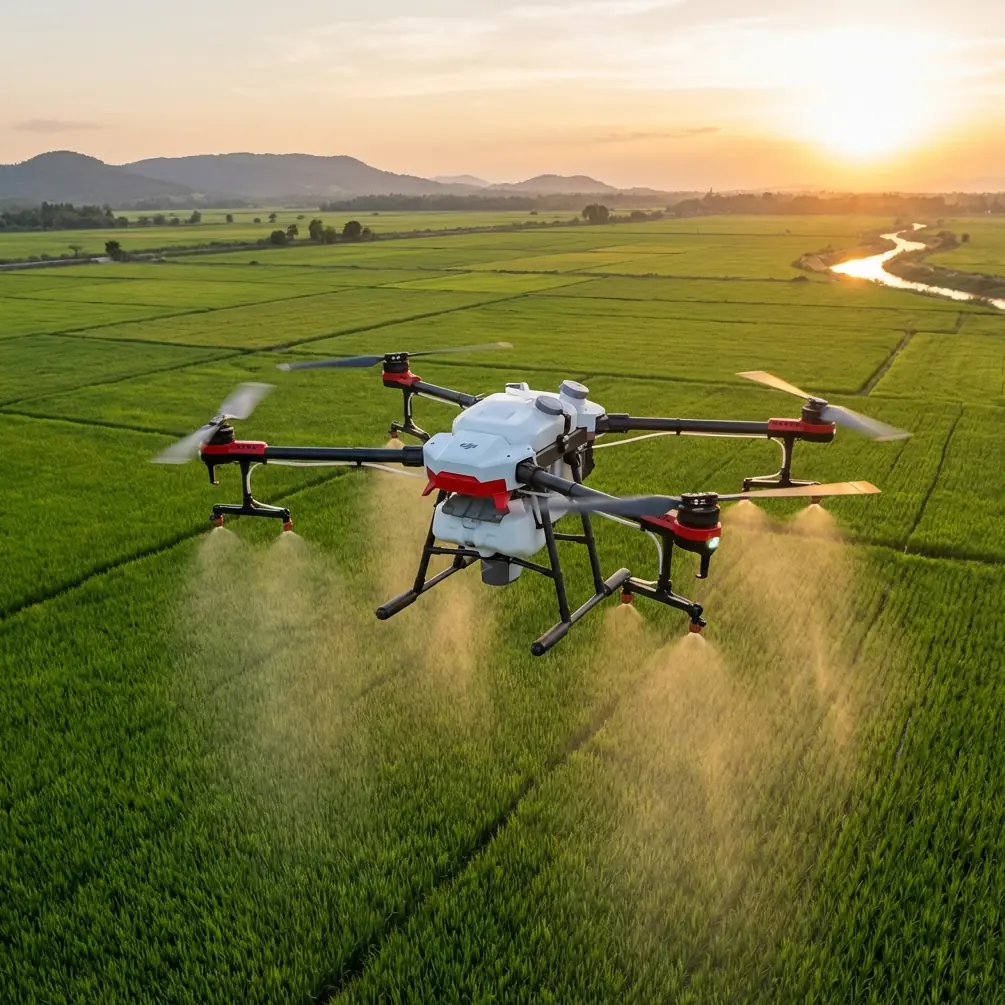
Coastal forest work looks deceptively simple from a distance. Trees, shoreline, maybe a boardwalk or access road, and a drone in the air for a few quick passes. That version exists mostly on paper. In the field, the job is messier. Wind shifts off the water. Tree crowns overlap in irregular layers. Light bounces from wet leaves one minute and drops under cloud cover the next. Add salt haze, narrow launch points, and the need to document change without disturbing a fragile environment, and the aircraft matters more than the spec sheet suggests.
That is the context where Flip starts to make sense.
I came to that view the hard way. Years ago, while photographing and documenting a coastal woodland edge after a storm season, I was working with a small drone that handled open spaces well enough but became tense and awkward as soon as I moved closer to canopy lines. The mission itself was straightforward: record tree loss, identify erosion patterns near the forest margin, and capture repeatable angles for future comparison. The reality was a stop-start operation. Every lateral move near branches demanded exaggerated caution. Tracking a path along the edge of the forest felt less like observation and more like negotiation.
The problem was not just safety. It was continuity. Forest monitoring depends on consistent visual data. If the aircraft hesitates, drifts, or forces the pilot to keep breaking framing decisions into tiny corrections, the result is fragmented documentation. You can still get images, but not always the kind that hold up when you need to compare canopy density, storm damage, invasive spread, or changes in water intrusion over time.
Flip changes that workflow because it addresses the exact pain points that tend to surface in coastal forest operations: close-proximity flight, moving perspective through cluttered environments, and the need to gather useful visual evidence without turning every sortie into a manual precision test.
The first operational shift is obstacle avoidance. In a coastal forest, this is not a marketing bullet. It is workload reduction. Branches do not present themselves as neat vertical barriers. You deal with mangrove-like tangles, leaning trunks, deadwood protrusions, and irregular understory gaps that appear open until your angle changes. A drone that helps manage that spatial uncertainty allows the operator to think more clearly about the mission itself.
That matters when the aim is environmental monitoring rather than pure image capture. If I am documenting a transitional zone where saltwater is pushing farther inland, I need attention on tree stress indicators, ground saturation, and shoreline geometry. I do not want most of my mental energy consumed by branch avoidance. Flip’s value in that environment is that it lets the pilot allocate more focus to the forest and less to constant micro-defensive flying.
Subject tracking is the second piece that becomes surprisingly useful. People often associate tracking features with action content, but in forestry work, tracking can help maintain continuity on a moving line or a repeating reference subject. Think of following the curve of a drainage channel through a stand of trees, keeping a ranger or field ecologist framed while they inspect affected areas, or preserving a stable relationship to a specific canopy section while moving along the forest edge. ActiveTrack, in practical use, is not about flashy autonomy. It is about reducing the number of small manual inputs that can introduce inconsistency.
That consistency is what makes before-and-after analysis stronger. If you are monitoring storm recovery or seasonal dieback, repeated camera movement patterns are often more valuable than isolated hero shots. Flip helps build that repeatability.
Then there is the matter of speed. Coastal windows close quickly. Tides change access. Weather shifts. Light can flatten detail over a whole section of woodland in minutes. When a drone includes QuickShots and Hyperlapse, the temptation is to think of them as convenience tools for polished content. In real monitoring work, they can be much more useful than that.
QuickShots can help generate standardized overview sequences with minimal setup, especially when time on site is limited. A repeatable automated move around a forest patch, dune edge, or estuary boundary can create visual references that are easier to compare across dates. Hyperlapse has a similar practical advantage. In coastal forests where change is slow to the eye but meaningful across hours or days—cloud shadows moving over stressed canopy, water levels shifting through root systems, human activity near access paths—time-compressed footage can reveal patterns that are easy to miss in still frames or short clips.
For a photographer, though, one of the most significant advantages is D-Log. Coastal forests produce difficult tonal scenes. You might have bright sky over reflective water on one side and deep greens under canopy on the other. Standard profiles can look attractive immediately, but they often compress the scene into something less flexible later. D-Log preserves more room for adjustment, which matters if your images are meant to support interpretation rather than just appearance.
That distinction deserves emphasis. Monitoring forests in coastal areas is not only about making beautiful footage. It is about creating material that can withstand scrutiny. If a conservation group, land manager, or restoration team needs to look closely at crown thinning, sediment deposition, or the progression of edge erosion, color and dynamic range are not artistic afterthoughts. They directly affect legibility.
I have seen this become decisive when comparing footage across seasons. A standard baked-in look might exaggerate contrast in one month and flatten shadow detail in another, making the forest appear more dramatically changed than it really is. With D-Log, there is a better chance of building a more controlled visual record from one survey to the next.
The “Flip” story becomes even more relevant when you step back and consider why continuity and traceability matter in field documentation at all. The reference context around this discussion points to a broader dispute over oil transit through Ukraine into the European Union, with President Volodymyr Zelensky arguing that restoring the flow would effectively mean easing sanctions on Russia. Whatever one’s focus within that geopolitical row, one operational lesson stands out: infrastructure, land corridors, and environmental interfaces can become central evidence in larger public debates.
That is highly relevant to civilian drone practice. A pipeline crossing territory, and the tension around whether flow should resume, shows how physical landscapes often sit inside wider economic and policy conflicts. For environmental professionals, that means documentation is not abstract. Accurate imagery of forests, wetlands, access corridors, and surrounding terrain can become part of how land use, resource pressure, or ecological risk is understood. When tensions rise around energy supplies and sanctions policy, as described in the reference material, landscapes near transport and coastal systems often face increased scrutiny. Reliable aerial documentation becomes more valuable, not less.
I am not suggesting coastal forest monitoring is the same thing as covering a geopolitical dispute. It is not. But the significance of the reference details is clear. First, the dispute centers on a pipeline route crossing Ukrainian territory into the EU. That is a reminder that environmental monitoring often intersects with infrastructure geography. Second, Zelensky’s statement that resuming oil flow would amount to lifting sanctions underlines how heavily the meaning of physical movement through a corridor can be contested. For civilian drone operators, the operational takeaway is simple: if your work involves documenting landscapes connected to transport, energy, or conservation concerns, clarity and repeatability in visual evidence matter.
That is one reason I prefer tools that reduce friction rather than add drama. Flip fits a monitoring mindset because it helps produce orderly outputs from disorderly spaces.
A practical coastal workflow with Flip usually starts before takeoff. I look for a launch zone that gives a clean vertical departure path and at least one fallback landing option if wind conditions change. Then I map three categories of shots: broad context passes, edge-tracking passes, and detail-focused low-altitude work near individual trees or erosion lines. The broad passes establish the relationship between forest and shoreline. The edge-tracking passes reveal how the boundary is behaving. The detail work captures the evidence that explains what the wide shots suggest.
This is where obstacle avoidance and ActiveTrack support each other. On edge-tracking runs, I want smooth motion beside the canopy without repeated braking and reframing. If I am following a footpath, drainage line, or person conducting a ground assessment, tracking helps preserve composition. Obstacle sensing reduces the feeling that every few meters might become a recovery exercise. The combination is not about removing pilot responsibility. It is about allowing the pilot to maintain concentration on interpretation.
QuickShots are most useful to me at the end of a survey block. Once I have the mission-critical material, I use them to capture a standardized perspective around a selected point of interest, such as a damaged stand, exposed root zone, or restoration site. Over time, those automated moves can become a very efficient visual archive. Hyperlapse is different. I use it when the story involves movement through time rather than just space—rising tide against a forest edge, cloud-driven light behavior over a recovering canopy, or the rhythm of activity around a coastal access point.
And because I come from a photography background, I have little patience for footage that looks good at first glance but collapses in post. D-Log gives breathing room. That matters on overcast mornings, in high-glare afternoon sessions, and in mixed scenes where one part of the frame wants to blow out while another disappears into shade.
There is also a softer benefit that is easy to overlook: confidence changes decision-making. When the aircraft behaves predictably in tight environmental conditions, you are more likely to attempt the shot that actually tells the story. Not reckless shots. Necessary ones. The line tracing where healthy canopy gives way to salt stress. The slow reveal of a creek mouth cutting deeper into the forest margin. The parallel movement that shows how a path, drainage feature, and tree line interact.
Those are the shots that used to take me several attempts. With Flip, they become more attainable on the first pass, and that has a cumulative effect on the whole day’s work.
If you are planning a coastal forest monitoring workflow and want to compare setup ideas or field routines, you can message here and continue the discussion in a practical way.
The strongest case for Flip is not that it turns difficult environments into easy ones. Coastal forests will always demand judgment. Wind, moisture, clutter, and access constraints do not disappear because the drone is smarter. The real advantage is that Flip removes enough friction to let a careful operator work with greater consistency. In monitoring, consistency is the difference between attractive footage and useful evidence.
For readers approaching this from photography, that means more controlled color, steadier framing, and less time wrestling with the aircraft. For conservation teams, it means clearer repeat surveys. For land managers, it means more dependable visual records of shoreline pressure, canopy condition, and site access. For anyone documenting how coastal forests are changing, it means the drone is less of a barrier between the observer and the landscape.
That is why Flip earns attention here. Not because it promises magic, but because in a place where branches, wind, water, and light all compete for control, it gives some of that control back to the operator.
Ready for your own Flip? Contact our team for expert consultation.