How Flip Helps You Scout Windy Fields Without Losing the Dat
How Flip Helps You Scout Windy Fields Without Losing the Data That Matters
META: A practical expert look at using Flip for windy field scouting, with a focus on safer capture, automated flight confidence, and photogrammetry-ready outputs for mapping and measurement.
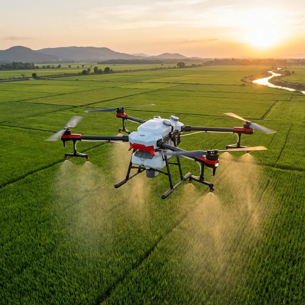
Wind changes everything in field scouting.
Not in theory. In practice. It changes how confidently you launch, how steadily you frame a tree line or drainage edge, and whether the imagery you bring home is useful for actual analysis or just visually pleasing clutter. For anyone scouting open ground with Flip, especially in gusty agricultural or rural conditions, the real question is not whether the drone can get airborne. It is whether the mission still produces usable mapping data when the air is messy.
That distinction matters more than most buyers realize.
As a photographer, I care about motion, light, and composition. But when I am scouting fields, those instincts have to coexist with something stricter: data discipline. A drone pass over a property is not just about spotting crop variation or checking access roads. It is often the first layer in a broader workflow that may later require orthomosaics, contour interpretation, surface measurements, and 3D review. That is where Flip becomes more interesting than a simple camera platform. In windy conditions, a capable aircraft is only half the story. The rest depends on what the imagery can become after landing.
The real problem with windy field scouting
Open fields are deceptive. They look simple from the ground, but they are one of the harder environments to scout well.
There are few visual anchors. Wind exposure is usually constant. Tree belts, utility lines, irrigation hardware, and uneven terrain can create abrupt localized turbulence. If you are trying to document drainage channels, crop stress patterns, bare patches, or boundaries, small inconsistencies in flight path and image overlap can compromise the output. A smooth-looking video clip does not automatically translate into reliable survey-grade interpretation.
That is why automated capture behavior and post-processing compatibility deserve more attention than they usually get in casual drone discussions.
Flip is often considered through the lens of intelligent flying features such as obstacle avoidance, subject tracking, QuickShots, Hyperlapse, D-Log, and ActiveTrack. Those are valuable, but windy field scouting pushes you toward a different standard. You need flight assistance that reduces pilot workload while preserving image consistency. The less mental bandwidth you spend wrestling the aircraft, the more attention you can devote to what the field is telling you.
A wildlife moment that proved the point
On one windy afternoon near a rough field margin, I was tracking a low path along a hedgerow to inspect water pooling and damaged vegetation after a storm cycle. Midway through the run, two deer broke from cover and crossed toward the open section of the field. A less stable setup can turn that into exactly the kind of moment that causes overcorrection: sudden stick input, poor framing, shaky altitude control, and a broken image sequence.
What mattered was not cinematic drama. It was composure.
Flip’s sensing and obstacle awareness gave me enough confidence to hold the line, maintain separation from the hedgerow, and avoid turning the whole pass into a salvage operation. That one moment is a good example of why sensor support is not just a convenience feature. In real field scouting, it protects continuity. If your mission is to assess land conditions in one efficient sortie, interruptions matter. They show up later in the map, in the model, and in the time you waste trying to patch missing coverage.
Why the mapping workflow matters more than people think
Here is the piece many field operators skip: the value of a scouting mission depends heavily on what your software can extract from the imagery.
The reference material behind the UX-1000 recommended workflow is revealing because it emphasizes not just flying, but what happens next. One of the highlighted platforms, ImageMaster UAS from Topcon, is described as a fully automated UAV data processing environment for surveying. Its workflow includes automatic photo alignment and stereo mosaicking, automatic TIN creation and texture generation, and automated contour and cross-section processing. That is not a small feature list. It defines the difference between “I flew the field” and “I can interpret and measure the field.”
Operationally, this matters because windy conditions can already tax your image set. If your downstream software can automatically build a TIN surface, generate orthographic imagery, and support point, line, and surface measurements, the field scout becomes much more than a visual check. You can calculate distance, area, and volume from the mission data. For land managers, agronomists, drainage planners, and rural site consultants, those outputs are where the drone starts paying for itself in time and clarity.
ImageMaster UAS also supports output formats including RGB point clouds, VRML, DXF, TIN, and ASCII. That detail is easy to overlook, but it has direct significance in field operations. Export flexibility means the images you captured with Flip do not get trapped inside one viewing app. They can move into CAD workflows, terrain studies, reporting environments, or broader GIS-based analysis. For scouting in windy locations, that kind of interoperability is insurance. If conditions are tough, every successful mission needs to produce data that can be reused across teams and software stacks.
What “fully automated” actually changes in the field
Automation is often advertised loosely. In this context, it means something specific.
The reference also points to Agisoft PhotoScan as a tool capable of fully automated image orientation and 3D reconstruction, with no need to preset initial values and no requirement for camera calibration in the basic workflow. More importantly, it can produce high-resolution true orthophotos, and with control points it can reach 5 cm accuracy. That number should stand out.
Five-centimeter accuracy is not a marketing flourish. For field scouting, it is the threshold where patterns start becoming decision-ready. Track marks, drainage incisions, missed patches, localized erosion, and access edge changes can be interpreted with confidence when the map product is tight enough. Even if a Flip mission begins as a quick windy-day reconnaissance flight, the ability to route imagery into a workflow that can approach 5 cm accuracy with control points changes the mission’s value. You are no longer just observing. You are creating a record that can support planning and comparison over time.
PhotoScan is also noted as capable of processing hundreds or even thousands of aerial images on a single computer, even for non-specialists. That point is operationally significant for a very simple reason: field scouting is repetitive. The usefulness is not in one flight, but in repeatability. If a grower, consultant, or land manager can run regular missions and process large image batches without a specialized photogrammetry team, Flip becomes part of a routine, not a one-off experiment.
Where Flip fits into this workflow
Flip’s role in windy field scouting is to lower the capture risk at the front end.
That includes stabilized image acquisition, intelligent tracking when you are documenting moving assets or following field boundaries, and obstacle-awareness support when your route includes tree lines, outbuildings, poles, or irregular margins. Features often associated with creative flying, such as ActiveTrack or QuickShots, are not the main event for mapping work, but they reveal something useful about the aircraft’s brain: it is designed to interpret motion and maintain controlled flight behavior under changing conditions.
That confidence matters when you are trying to preserve overlap and consistency in gusts.
D-Log also has a place here, though not for the usual reason. People talk about flat color profiles in terms of grading flexibility. In field scouting, the benefit is often tonal retention. If you are documenting mixed surfaces under harsh daylight—bare soil, wet patches, vegetation, gravel access paths, reflective standing water—retaining image information can help during interpretation and reporting. Not every field mission needs stylized footage. Many need readable, gradable, evidence-rich imagery.
Hyperlapse has niche value as well. I would not treat it as a core scouting function, but for documenting change along access corridors, perimeter roads, or seasonal field development, it can add context that standard stills do not provide.
Why windy scouting demands a problem-solution mindset
The mistake is to think of wind as a nuisance rather than a planning variable.
If the problem is unstable field capture, the solution is not simply “buy a better drone.” The solution is to build a workflow where airborne stability, route discipline, and robust processing all support one another.
That means:
- Fly with enough margin around tree lines and structures for obstacle systems to help rather than rescue.
- Prioritize repeatable passes over improvisation.
- Capture with post-processing in mind, not just visual appeal.
- Use software capable of automated alignment, orthomosaic generation, terrain modeling, and measurement.
- Preserve export options so field data can serve mapping, planning, and reporting later.
The reference material reinforces this systems view. Pix4D Mapper, for example, is described as a fully automated and fast platform for turning thousands of images into accurate 2D maps and 3D models without manual intervention or specialist knowledge. For a Flip operator, that means the drone can be used by someone whose main skill is field observation rather than formal photogrammetry. In windy environments, that is a practical advantage. You already have enough variables outdoors. Reducing software friction is not a luxury.
What this means for actual field users
If you scout agricultural blocks, rural properties, construction-adjacent land, or undeveloped sites, the best use of Flip is not as a flying camera alone. It is as the image acquisition end of a decision workflow.
A windy mission over a field can lead to:
- a true orthophoto for boundary or crop-zone review,
- a textured DEM for terrain interpretation,
- a TIN model for surface understanding,
- contour and cross-section outputs for drainage assessment,
- line, surface, area, and volume measurements for planning,
- RGB point cloud exports for deeper technical analysis.
Those possibilities are grounded directly in the referenced processing ecosystem, not abstract drone hype.
And this is why a stable, sensor-aware aircraft matters so much. Data products like orthomosaics and 3D terrain models are unforgiving. They expose weak capture habits fast. Flip gives the pilot a better shot at returning with coherent imagery when the field is windy, the margin is busy, and the job needs to be done in one visit.
A more honest way to evaluate Flip
If you are choosing Flip for field scouting, ask a harder question than “How good is the camera?”
Ask this instead: can the images I collect in imperfect wind feed a workflow that produces measurable, shareable, technically useful outputs?
Based on the reference stack, that is the right lens. ImageMaster UAS emphasizes automated photo orientation, TIN generation, contours, sections, 3D model editing, and export breadth. PhotoScan adds automated reconstruction and true orthophoto generation with up to 5 cm accuracy when control points are used. Pix4D Mapper reinforces the same theme from another angle: speed, automation, and professional-grade 2D and 3D deliverables from large image sets.
Put those pieces together, and Flip becomes less about gadget appeal and more about field intelligence.
If you want to talk through a practical windy-field setup, capture strategy, or software path for your own operation, you can message a specialist here.
The best field drones are not the ones that merely survive tough air. They are the ones that return with imagery that still means something after the landing.
Ready for your own Flip? Contact our team for expert consultation.