Scouting High-Altitude Vineyards With Flip
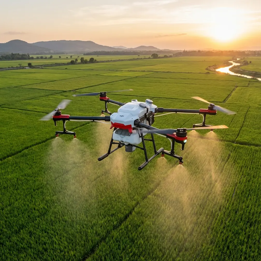
Scouting High-Altitude Vineyards With Flip: Why Light Matters More Than Specs
META: A practical expert guide to using Flip for high-altitude vineyard scouting, with a photographer’s take on natural light, tracking, obstacle awareness, and fast aerial workflows.
High-altitude vineyards can make even a seasoned drone operator look clumsy.
The slopes are uneven. Rows tighten and bend around terrain. Light changes by the minute as clouds move across ridgelines. By the time you launch, frame a pass, and reposition, the scene you wanted may already be gone. That is exactly why scouting vineyards is not just about flying a capable drone. It is about seeing light correctly and using the aircraft’s automation without letting it flatten the story of the land.
I come at this as a photographer first. And one idea from a recent April 14, 2026 photography piece cuts through the noise better than most drone marketing ever does: light is the real language of imaging. That article centered on 8 field-tested smartphone shooting techniques, but its first and strongest point applies directly to aerial scouting with Flip. If you do not understand how to work with natural light, you waste the camera you already have. In vineyard work, that waste shows up as dull canopy texture, unreadable slope contours, and footage that tells you almost nothing useful about block condition.
Flip becomes far more interesting when you stop treating it as a flying gadget and start using it as a mobile light-reading tool.
The real problem in vineyard scouting
Most vineyard scouting flights fail in ordinary ways.
Operators fly at midday because it is convenient. They rely on default auto exposure. They chase symmetry instead of information. They collect footage that looks clean on a small screen but falls apart when a grower needs to read vigor differences, drainage patterns, row interruptions, or terrain access routes. High altitude only amplifies these mistakes. Haze can wash out contrast. Bright sky can trick the camera. Strong angle changes expose weak stabilization habits and poor route planning.
A lot of pilots respond by obsessing over specs. Bigger sensor. Higher bit rate. More modes.
That misses the point.
The stronger approach is operational: use Flip to capture repeatable, readable images under changing natural light, with flight modes that reduce pilot workload while preserving visual intent. For vineyard scouting, that combination matters more than raw feature count.
Why the “natural light first” mindset fits Flip so well
The smartphone photography source I referenced made a simple promise: practical methods over abstract theory. That framing is useful here because vineyard teams do not need romantic lectures about image-making. They need reliable habits that improve scouting output immediately.
The article’s first core lesson was that light is the foundation of all photography, and that cameras are highly sensitive to how natural light is used. That is especially true in aerial work over vines. At high altitude, natural light does not just illuminate the rows. It reveals structure.
Early or late angled light can separate one block from another by creating tiny shadows along canopy edges. It can help expose missing growth, row inconsistency, and subtle undulations in the soil surface. Flat overhead light often does the opposite. It erases texture and makes the whole property feel uniform when it is not.
With Flip, this becomes operationally significant in two ways.
First, a compact, quick-deploy aircraft is more likely to be launched at the right moment. Good light windows in mountain vineyards are often brief. You may get 20 minutes of beautifully directional light before a ridge shadow shifts or cloud cover closes in. A system that gets airborne quickly is not a convenience feature in that context. It is the difference between a scouting flight with diagnostic value and one that merely documents location.
Second, tools like D-Log give you more flexibility when the light range is difficult. Vineyard scenes often combine bright sky, reflective leaves, dark row interiors, and pale soil or rock. A flatter capture profile can preserve more room for balancing those elements later, especially when the goal is not just cinematic output but interpretable visual evidence.
Where Flip has an edge in the field
In vineyard environments, drone superiority rarely comes from one dramatic capability. It comes from how several small advantages stack up in real use.
Take obstacle avoidance. On paper, everyone likes to mention it. In the field, it becomes critical when you are running contour-following passes near terraces, access roads, trellises, outbuildings, tree lines, or utility edges. High-altitude vineyards are not open lawns. They are layered, irregular spaces. A drone that helps manage collision risk lets the operator spend more attention on framing, row continuity, and changing light instead of micromanaging every inch of movement.
The same logic applies to subject tracking and ActiveTrack. In a vineyard scouting context, “subject” does not have to mean a cyclist or vehicle in the consumer sense. It can mean following a utility path, a worker moving through a block for scale reference, or maintaining visual continuity on a target section of land while the aircraft adapts to terrain and perspective changes. That reduces the stop-start pattern many pilots fall into when conditions are windy or topography is awkward.
Compared with less refined tracking systems, Flip’s value is not that it removes the operator from the process. It is that it preserves momentum. In steep vineyard zones, preserving momentum matters because every unnecessary reposition eats battery, light, and concentration.
Then there is QuickShots. Some pilots dismiss automated modes as beginner tools. That is a mistake in commercial scouting. When used selectively, QuickShots can standardize certain establishing angles across multiple blocks or properties. That consistency is useful for teams building visual records over time. If one vineyard manager wants the same reveal or orbit each month from roughly the same vantage, an automated routine can improve repeatability more than a purely manual flight.
Hyperlapse deserves more credit too. Vineyards at elevation are deeply shaped by changing atmosphere: fog burn-off, shadow movement, wind through canopy, work activity, vehicle access patterns. Hyperlapse can compress those shifts into a form that makes environmental behavior easier to read. It is not just a stylistic trick. Used well, it can show how a site opens to sun, how cloud cover affects visibility, or how traffic flows through service roads during a work window.
Light, terrain, and why midday lies
If you scout vineyards long enough, you learn that midday can be dishonest.
Rows look neat. Green looks strong. Sky is bright. The footage feels crisp. Yet subtle problems disappear because direct overhead light removes the shadow information that helps define texture and depth. The April 2026 photography article argued against wasting a good camera by ignoring practical fundamentals. In aerial vineyard work, this is exactly what happens when operators fly only under harsh top light.
Flip gives you enough creative and operational control to avoid that trap, but only if you plan around light instead of convenience.
For block overview passes, I prefer side light whenever possible. It outlines row geometry and reveals slope shape. For road and access analysis, lower-angle light can make rutting and grade changes more visible. For canopy aesthetics or promotional tourism visuals, a backlit approach can be beautiful if exposure is managed carefully and the drone’s path is designed to avoid blown highlights.
This is where D-Log and disciplined exposure choices become more than a post-production luxury. They help protect detail in difficult transitions, especially when a flight path moves from dark hillside sections into open sky. If your scouting deliverable is going to be reviewed by growers, marketing teams, and operations staff, preserving flexibility in the image is worth the extra care.
A practical Flip workflow for vineyard scouting
My preferred workflow is simple and fast.
Arrive early enough to watch the light for a few minutes before launch. Look at which slopes are getting edge light and which are still flat. Identify one establishing sequence, one tracking sequence, and one slow descriptive pass over the most operationally relevant block.
Use Flip’s obstacle awareness and ActiveTrack features to reduce manual workload on tight movements, especially if you are flying along roads or contour lines with uneven terrain nearby. Save pure manual precision for moments that genuinely require artistic or technical control.
Capture one set of footage for utility and another for interpretation.
The utility set includes top-down or high oblique views that clearly show block layout, access routes, and terrain relationships. The interpretation set is where you use lower angles, side light, and selective movement to expose condition, shape, and atmosphere. QuickShots can help lock in repeatable establishing clips. Hyperlapse can record changing shadow or weather behavior over time. D-Log can preserve the tonal range needed for later analysis and presentation.
If you are coordinating with a remote team while on site, send sample frames or flight notes through a direct field channel like this WhatsApp contact line so decisions can be made while the light is still working in your favor.
That sounds minor. It is not. In high-altitude environments, delay costs more than battery. It costs the visual conditions you came for.
What Flip does better than many competitors in this scenario
A lot of competing drones can capture vineyard footage. Fewer feel genuinely efficient once terrain, wind variation, changing light, and the need for repeatable documentation all stack together.
That is where Flip stands out.
Its feature mix suits the actual rhythm of scouting. Obstacle avoidance helps in irregular agricultural spaces rather than just looking good on a spec sheet. ActiveTrack and subject tracking support continuity on routes and targets that matter in vineyard operations. QuickShots are not merely social features when they are used to standardize recurring visual records. Hyperlapse adds environmental time context. D-Log supports image integrity in difficult lighting.
The bigger distinction, though, is usability under pressure. In mountain vineyard work, the best drone is often the one that gets from launch to useful footage with the least friction. Competitors may offer similar check-box capabilities, yet still demand more pilot intervention, more setup time, or more compromise when the terrain gets awkward. Flip excels because its tools align with the pace of field scouting rather than interrupting it.
That practical alignment is easy to underestimate until you are standing on a steep access road, sun breaking through cloud, with one short window to record a block before shadow takes it.
The photographer’s lesson that drone operators forget
The 2026 smartphone photography piece promised 8 proven techniques and deliberately avoided dense theory. That spirit is worth carrying into drone work.
You do not need a mystical approach to create useful vineyard imagery. You need a disciplined one. Respect natural light. Use automation strategically. Build repeatable flight patterns. Capture for both analysis and storytelling. Let the terrain tell you where the shot should come from instead of forcing a generic aerial template onto every property.
That is why Flip works so well for this kind of assignment.
It supports the fundamentals instead of distracting from them.
And in high-altitude vineyards, fundamentals are what separate pretty footage from footage that actually helps someone understand the land.
Ready for your own Flip? Contact our team for expert consultation.