How to Survey Mountain Solar Farms with Flip Without Comprom
How to Survey Mountain Solar Farms with Flip Without Compromising Safety Data
META: A practical, field-driven guide to surveying mountain solar farms with Flip, focused on obstacle avoidance, pre-flight cleaning, ActiveTrack, D-Log, and safer workflows in complex terrain.
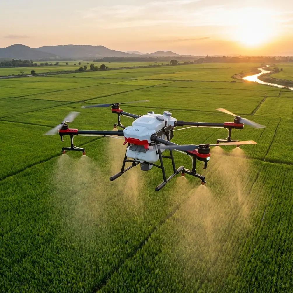
Mountain solar sites expose every weak point in a drone workflow. Steep access roads, changing light, wind funnels along ridgelines, panel glare, and uneven launch areas all combine to make a simple inspection harder than it looks on paper. If you are planning to survey a solar farm in this kind of terrain with Flip, the job is not just about getting airborne. It is about protecting image quality, preserving obstacle sensing performance, and building a repeatable process that still works when the mountain introduces variables you cannot control.
That matters now more than ever because drone operations have moved far beyond niche ownership. A widely cited FAA figure from 2016 put the number of drones in the United States at 600,000. That number helps explain why drone safety became such a visible topic: more aircraft in the air means tighter expectations around disciplined operations, cleaner workflows, and better use of onboard safety systems. For commercial users surveying energy assets, that shift is operational, not theoretical. The standard is no longer “can a drone do this job?” The standard is “can your team do it consistently, safely, and with usable outputs?”
For mountain solar work, Flip fits best when you treat it as a compact aerial survey tool rather than a casual camera platform. Features such as obstacle avoidance, subject tracking, QuickShots, Hyperlapse, D-Log, and ActiveTrack can all contribute value, but only if they are used deliberately. The hidden starting point is simpler than most crews admit: clean the aircraft before takeoff, especially the vision and sensing surfaces.
Start with the pre-flight cleaning step most teams rush
If Flip is being deployed around solar arrays in mountainous areas, it will collect dust faster than operators expect. Dry access tracks kick up grit. Pollen and fine soil cling to the body. Morning condensation can leave residue when it dries. On some sites, airborne debris from vegetation management or maintenance vehicles settles directly onto the front-facing and downward sensing areas.
That becomes a safety issue, not just a cosmetic one.
Obstacle avoidance depends on clean sensing surfaces and clear visibility. If the aircraft’s vision system is smeared with dust or fingerprints, the drone may hesitate unnecessarily, detect obstacles poorly, or produce inconsistent behavior near rows, cable trays, perimeter fencing, or inverter stations. In mountain solar environments, those objects can appear suddenly because of elevation changes and broken sightlines. A drone coming over a slight crest toward a line of panel tables has less margin than one working over flat farmland.
My preferred routine is straightforward:
- Wipe camera glass and obstacle sensing surfaces with a clean microfiber cloth before powering on.
- Check for dried water spots, especially after early morning setup.
- Inspect the underside for dust around downward sensors.
- Confirm propellers are free of grit or tiny edge nicks from transport.
- Look closely at arm joints and body seams if the aircraft was packed after a dusty mission.
This cleaning step is easy to skip because it adds only a minute or two. On a mountain solar job, those minutes protect the very systems you rely on when the site gets tight.
Build the mission around the terrain, not around the drone
Surveying a mountain solar farm is not the same as flying over a uniform utility-scale site on flat ground. The terrain changes your altitude relationship to the asset every few seconds. A pass that seems comfortably high at one edge of the array may bring the aircraft much closer to structures as the slope rises beneath it.
That is why the first planning principle with Flip is to define your survey objective before choosing your flight pattern.
Are you documenting:
- overall construction progress,
- panel row alignment,
- drainage conditions,
- vegetation encroachment,
- access road erosion,
- perimeter fencing,
- inverter pad conditions,
- or public-facing marketing footage for stakeholders?
Each objective changes how you use the aircraft.
If your goal is engineering review, stable manual flight with controlled overlap and consistent framing will matter more than cinematic movement. If the purpose is progress documentation for management, QuickShots and Hyperlapse may have a place, but only after the primary inspection footage is secured. Too many teams reverse the order and leave with beautiful sequences that are less useful than they expected.
Launch where the aircraft can see the site clearly
Mountain sites tempt operators into poor launch choices. A convenient turnout or a narrow patch near a service vehicle may seem fine, but if the area is cramped by brush, fencing, or equipment pallets, you are immediately asking more from obstacle sensing during takeoff and landing.
Choose a launch spot with:
- a stable, level surface,
- enough open space above and ahead of the aircraft,
- a clear visual line toward the first segment of the survey area,
- and separation from loose dust or reflective surfaces.
The reflective point deserves attention. Solar panels and bright metal components can create visual complexity, especially when the sun angle is low. Flip’s camera can handle a lot, but reflections still complicate exposure decisions and visual assessment in the live view. Starting from a position that gives you a clean read on the site helps you make better first-pass decisions.
Use obstacle avoidance as a margin tool, not as a substitute for judgment
Obstacle avoidance is one of the most useful features for this kind of mission, but it is often misunderstood. On mountain solar sites, it is best treated as an extra layer of protection rather than permission to fly aggressively between structures.
The operational significance is simple: the mountain changes closure rate and sightline geometry. A drone moving laterally across sloped terrain can encounter poles, terrain edges, guy wires, or isolated maintenance structures in ways that feel visually compressed from the pilot’s perspective. Obstacle sensing helps catch some of that complexity, but it works best when the aircraft is already being flown conservatively.
Practical approach:
- Make your first pass higher and slower than you think you need.
- Identify terrain rises, narrow row gaps, and problem reflections.
- Only then step down to lower-detail passes if the objective requires them.
- Maintain wider separation from panel rows than you would on level ground.
For solar farms specifically, the danger is not just collision. Sudden braking or rerouting from obstacle avoidance can interrupt your framing or overlap pattern, which affects the quality of survey records. If you are documenting panel conditions row by row, consistency matters as much as safety.
When ActiveTrack and subject tracking help on infrastructure jobs
At first glance, subject tracking and ActiveTrack sound more relevant to moving people or vehicles than to energy infrastructure. Used carefully, though, they can support specific mountain-site workflows.
For example, if a technician or site vehicle is moving along a maintenance route and you need contextual footage showing access conditions, drainage issues, or row-side clearance, ActiveTrack can reduce pilot workload while keeping the visual narrative coherent. It is especially useful when the terrain forces constant micro-adjustments in manual framing.
But this only works well if the operating area is open enough and the route is predictable. Do not force tracking into dense structure environments or tight corridors between equipment clusters. The value of ActiveTrack on a solar site is not novelty. It is continuity. It lets you document how people and vehicles interact with difficult terrain without splitting your attention between path management and framing every second.
The same caution applies to general subject tracking. Keep it for supportive documentation, not for the primary inspection record.
Capture your inspection footage first, then use QuickShots and Hyperlapse selectively
QuickShots and Hyperlapse can be useful on mountain solar projects, but only after the inspection mission is complete.
QuickShots are best reserved for stakeholder communication: a concise reveal of the site’s scale, a route approach sequence, or a clean orbit showing how the array sits against the terrain. Those clips can help project managers, investors, or community stakeholders understand the site layout far faster than static photos.
Hyperlapse is different. On a mountain solar site, it can be a powerful progress tool when used from a repeatable vantage. If you return to the same location over multiple visits and maintain similar framing, you can build a time-based visual record of construction phases, vegetation changes, drainage performance, or snow retreat patterns.
The key is discipline. Hyperlapse should come from a location where wind, sunlight angle, and line of sight are manageable. Otherwise, it becomes a flashy file that contributes little to asset understanding.
Use D-Log when lighting across the slope won’t stay consistent
Solar farms in mountains rarely give you uniform light. One row may be under soft cloud shadow while the next reflects hard sunlight. Ridges cast moving bands of shade. White balance and contrast can shift dramatically during a single flight.
This is where D-Log earns its place.
The operational significance of D-Log is not abstract “cinematic quality.” It is latitude. When your footage includes bright panel reflections, dark ground cover, and mixed shadow across a steep slope, a flatter profile preserves more flexibility for later balancing and interpretation. If your workflow includes post-processing for reporting or client presentation, this can help maintain detail in difficult scenes.
That said, do not use D-Log casually if your team is not prepared to process it properly. If the output must be reviewed immediately in the field by non-editors, standard profiles may be more practical for some flights. The right answer depends on whether the mission is inspection-first, reporting-first, or presentation-first.
A mountain solar survey workflow that works in the field
Here is the sequence I recommend for Flip on these jobs:
1. Site arrival and environmental read
Walk the launch zone and scan the array from ground level. Check wind direction, sun angle, dust sources, and likely terrain blind spots.
2. Pre-flight cleaning
Clean the camera and all sensing surfaces before power-up. This step directly supports obstacle avoidance reliability.
3. Aircraft and route check
Confirm battery status, home point logic, route intention, and return path relative to rising terrain.
4. High reconnaissance pass
Fly a slower, higher orbit or edge pass to understand elevation transitions and identify obstacles that are hard to read from the ground.
5. Primary documentation pass
Capture the rows, access roads, drainage features, and infrastructure zones that matter for the survey objective.
6. Targeted low-detail pass if needed
Only move lower if you need closer visual review and the terrain relationship is fully understood.
7. Supplemental automation
Use ActiveTrack, QuickShots, or Hyperlapse only for supporting documentation after the core survey is complete.
8. Landing and post-flight inspection
Check the aircraft again for dust accumulation, especially if you plan a second sortie. Mountain solar sites can contaminate sensors quickly between flights.
Why this discipline matters more today than it did a few years ago
The rise of drones from niche tools to mass-use aircraft changed expectations around professionalism. The older image of drones as specialty machines for a few well-funded users has been replaced by broad adoption across consumer and commercial work. That transition is one reason safety remains such a central topic. When a platform category grows this quickly, operational habits become the real differentiator.
That is also why small details like pre-flight cleaning now deserve more attention than they usually get. With hundreds of thousands of aircraft in circulation even back in 2016, the industry was already moving toward procedural maturity. In commercial inspection, mature operators are not the ones who simply know which buttons to press. They are the ones who build workflows that account for dust, glare, slope, repeatability, and human error before the aircraft leaves the ground.
If your team is refining a mountain solar workflow around Flip and wants to compare field setups or mission planning ideas, you can message us here.
The practical takeaway for Flip operators
Flip can be very effective on mountain solar sites, but the aircraft will reward discipline more than improvisation. Obstacle avoidance helps, yet it depends on clean sensors and conservative spacing. ActiveTrack and subject tracking can support contextual documentation, but they should not drive the mission. QuickShots and Hyperlapse have value when stakeholder communication or progress storytelling is part of the deliverable. D-Log becomes especially useful when slope-based lighting contrast starts to fight your footage.
If I had to reduce the whole method to one principle, it would be this: treat the first minute on site as part of the survey, not as dead time before the flight. The cleaning step, the launch selection, and the first high pass determine whether the rest of the mission feels controlled or reactive.
On mountain solar farms, that difference shows up in both safety and data quality.
Ready for your own Flip? Contact our team for expert consultation.